Route Editor

| Guide | ♦ | 10 Triplogs | 1 Topic |
details | drive | no permit | forecast | route |
stats |
photos | triplogs | topic | location |
| 71 | 10 | 1 |
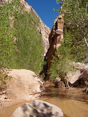
Beautiful canyon dayhike by PaleoRob  Hackberry Canyon is one of the most popular of the Cottonwood Canyon Road hikes, and it is done generally one of two ways. The first is as a dayhike into the lower part of Hackberry Canyon, and the other is as a through-hike up Hackberry Canyon to Round Valley Draw. This description will cover the lower portion of Hackberry.
As you move upcanyon, you are passing through the geologic formation known as The Cockscomb. Here the layers of rock, normally horizontal, have been pushed towards vertical when the Kaibab Monocline was uplifted. Streams already flowing in the area, like the Paria River, cut across the uplifting rocks, while new streams like Hackberry were forced to carve their courses through the softest rock they could find. As you hike upcanyon you are first walking through the Navajo Formation, which is primarily white in color in this area. Further upstream, around 1.75 miles from the trailhead, you start getting into the red Moenave Formation. Most day hikers generally turn around and return to their vehicles after 2 miles or so, but the stream in the canyon is present in the lower 10 miles of the canyon. Monsoon storms can also turn CCR into a quagmire, so even if you don't get flooded out of Hackberry Canyon, you may not be able to leave the parking area! Make sure to check in with with the visitor's center in Big Water, Utah, on the current road conditions before leaving on this hike. Another potential danger is quicksand. While generally not a threat to life and limb, it can be a scary experience. If you encounter sand or mud that seems "springy" or notice that the sand appears to flow into footprints and such, make sure you keep moving. If you have to slow down and begin to get stuck, move slowly, don't panic, and increase your surface area on the quicksand by laying down and crawling to dry ground. Generally, however, quicksand in Hackberry is shallow and sporadic, and usually easily avoided. Check out the Official Route and Triplogs. Leave No Trace and +Add a Triplog after your hike to support this local community. | |||||||||||||||||||||||||||||||||||||||||||||||||||||||||||||||||||||||||||||||||||||