Route Editor

| Guide | ♦ | 15 Triplogs | 0 Topics |
details | drive | no permit | forecast | route |
stats |
photos | triplogs | topics | location |
| 95 | 15 | 0 |
Canyons are inherently risky. Flash floods occur without notice on sunny days. Technical skills & surrounding topography knowledge required yet does not eliminate risk.
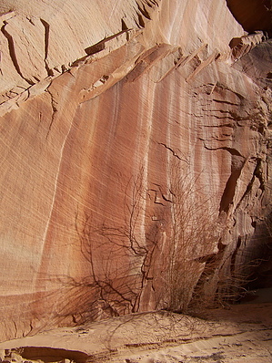
Quick, narrow canyon hike by PaleoRob  Cottonwood Canyon Road, located in the western portion of the Grand Staircase-Escalante, is a major connecting route between US89 that runs between Kanab, Page and UT12. It runs between Bryce Canyon and Boulder. CCR also serves as primary access to the popular hikes in the western monument. One such hike is the short jaunt up the Cottonwood Canyon Narrows. There are two trailhead options, one at 24.4 miles up CCR from US89, while the other is a mile further north on CCR. While the upper end of Cottonwood Canyon Narrows may be more interesting for those looking for narrow canyon action, this hike will be described from the southern trailhead, as that is where my experience lays.
After parking at the signed trailhead parking area, descend to the wash bottom. The hiking for the first half mile will be in deep sand, so be prepared for that. Head upstream into the canyon ahead of you, after crossing under the power lines. The canyon walls are not terribly narrow at this point, and in fact are not very steep in places, allowing you to climb out of the canyon, if you so wish, to survey the scene around you. What the lower canyon lacks in narrowness, however, it makes up in other geological oddities. Arches, fins, hoodoos, and spires sprout from the canyon walls with regularity. Take time to stop and look around as you hike upcanyon. After about half a mile, the canyon begins to narrow, and "slot up." If you've come expecting a slot canyon the likes of Antelope or Waterholes Canyons, or even Willis Creek, you'll likely be disappointed. The walls get tall, the lower portions get sculpted-looking, but it never achieves the feel of a true slot. None the less, it is pretty neat. The beginning of the true narrows, when you're hiking upcanyon, begins at the Great Vault, an enormous alcove tucked just up under the rim of the canyon on the west side. Someday (perhaps soon?) this will form an arch as the center continues to erode. For now, its just another funky geologic anomaly to chalk up on your hike. The canyon bottom gets rockier at this point, and scrambling over boulders may be required at various points. The walls continue to narrow and if you're hiking late in the day, you may feel like you're walking in a tunnel where no light reaches the canyon bottom. A few more fins and arches appear on the canyon rim. Even in late April you may find some snow in the canyon bottom, where the sun never reaches. Eventually the canyon starts widening again. Small boulder falls cross the creek bottom, scrambling up 5 feet of boulders may be required. Dogs shouldn't have a problem with this, however, provided they are in good shape and can jump moderate distances. The canyon suddenly opens, cutting back through to the east side of The Cockscomb. A dark slot takes off to the left, while a sandy wash continues straight ahead, and power lines become visible again. This is the end of the hike. Follow the sandy wash out of The Cockscomb, and climb the embankment to the road. If you've shuttled a car to this point, hop in and drive south to the original trailhead. Otherwise hike back to the trailhead on the road one mile to the south. If you want to walk back through the canyon, the total round-trip distance becomes 3 miles. Exploration of the few blind slot side-canyons off Cottonwood Canyon Narrows, that you'll see on your hike, will increase the distance a little bit more as well, depending on which ones you enter and how far you hike them. Note This is a dry hike - bring all the water you'll need. There is also a serious flash-flood danger for this canyon during monsoons. Be aware of the weather. Be sure to stop at the Big Water Visitor's Center before heading out to check on the latest road and canyon conditions. Check out the Official Route and Triplogs. Leave No Trace and +Add a Triplog after your canyon trip to support this local community. | ||||||||||||||||||||||||||||||||||||||||||||||||||||||||||||||||||||||||||||||||||||||||||||||||||||||||||||||||||||||||||||||||||||||||||||||||||||||||||||||||||||||||||||||||||||||||||||||||