 Route Editor

| Guide | ♦ | 161 Triplogs | 0 Topics |
details | drive | permit | forecast | route |
stats |
photos | triplogs | topics | location |
| 204 | 161 | 0 |
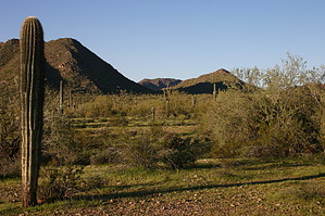
Rewarding Views by ferazamboni  The Goldmine Trail is one of the more popular trails in the San Tan Mountain Regional Park. This is likely due to the elevation gain and rewarding views. The Goldmine Trail is one of the more popular trails in the San Tan Mountain Regional Park. This is likely due to the elevation gain and rewarding views.There are two ways to access this hike, one of which is from the Goldmine Trailhead located at the intersection of Skyline and Wagon Wheel roads on the North end of the park boundary. The second access point is via the larger Visitor Center located on the East end of the park at the end of Phillips road. If you're looking for a quick workout, the Goldmine Trailhead is your best bet. However, if you plan on exploring other parts of the park, you might consider accessing it from the Visitor Center. This trail description is from the Visitor Center.
The Goldmine Trail starts out heading East from the Visitor Center along a wide, flat, dirt trail that is well marked and easy to follow. It soon curves North East and continues flat for about 0.7 miles until its junction with the Little Leaf Trail. From the junction with the Little Leaf Trail, it continues North with a moderate incline for another 0.4 miles until its junction with the San Tan Trail. The trail continues North East from this point for another 0.5 miles as it steadily climbs to a saddle between peaks in Goldmine Mountain. At the saddle, there are benches where you can rest and enjoy the view to the East. The trail continues along the ridge for another 0.25 mile to another resting point that presents views to the North and West. From here, you can sigh at all the hustle and bustle going on in the Phoenix metro area as you enjoy the peace and quiet of the park. From the second viewpoint, the trail descends the North West side of the mountain for a 0.75 mile before reaching the other Goldmine Trailhead on the northern park boundary. This section of the trail is quite rocky, and one should take care, especially when descending. Near the North Goldmine Trailhead, there is an interesting gravesite where some prospectors were buried. The return route is the way you came unless you have a car shuttle at the opposite trailhead. The park Visitor Center has a nice memorial of the Arizona residents who lost their lives in Iraq and Afghanistan.
Check out the Official Route and Triplogs. Leave No Trace and +Add a Triplog after your hike to support this local community. One-Way Notice This hike is listed as One-Way. When hiking several trails on a single "hike", log it with a generic name that describes the hike. Then link the trails traveled, check out the example. | ||||||||||||||||||||||||||||||||||||||||||||||||||||||||||||||||||||||||||||||||||||||||||||||||||||||||||||||||||||||||||||||||||||||||||||||||||||||||||||||||||||||||||||||||||||||||


