 Route Editor

| Guide | ♦ | 15 Triplogs | 0 Topics |
details | drive | no permit | forecast | 🔥 route |
stats |
photos | triplogs | topics | location |
| 0 | 15 | 0 |
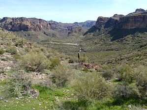
Where did it go George? by nonot  Overview OverviewThis is a connector between the Bull Pass trail and the Dutchman. History A lost trail in the Superstitions? Say it isn't so!
I can understand why caves and ruins are not listed on maps, as each visitor has a degrading impact upon these fragile places. However, the pot hunters have long since gotten the booty, so further protection of these sites is laughable. And while I can sympathize with rescuers pulling people out of dangerous mines, I do not agree with the sealing of natural caves due to idiocy on behalf of a few bad apples, nor do I believe that non-social trails like this should be erased from history. I cannot take credit for finding it as people before I have stumbled upon it, thinking it was the Bull Pass Trail. Hike From near the departure point to the top of Black Top Mesa on the Bull Pass trail, on the east downslope, you will reach a fork in the trail. If you are observant, you will notice it. The Bull Pass trail is the northern branch, while this trail of mystery is the southern branch. The trail is in pretty good shape, all considered. Why was it erased from maps? Why does this trail not have a name? What is there to find nearby? I will not provide answers to all these questions. You have to get out there and do some exploration for yourself! Warning Please note, this small connector trail is in the middle of nowhere and will take you on at least an approximately 10-12 mile hike round trip, so be prepared. Do not set out there thinking the less than one mile in this trail description is all there is. Bring plenty of food and water, do not go in the scorching summer temps! Check out the Official Route and Triplogs. Leave No Trace and +Add a Triplog after your hike to support this local community. One-Way Notice This hike is listed as One-Way. When hiking several trails on a single "hike", log it with a generic name that describes the hike. Then link the trails traveled, check out the example. | |||||||||||||||||||||||||||||||||||||||||||||||||||||||||||||||||||||||||||||||||||||||||||||||||||||||||||||||||||||||||||||||||||||||||||||||||||||||||||||||||||||||||||||||||||||||||||||||||||||||||||||||||||||||


