 Route Editor

| Guide | ♦ | 7 Triplogs | 0 Topics |
details | drive | no permit | forecast | 🔥 route |
stats |
photos | triplogs | topics | location |
| 89 | 7 | 0 |
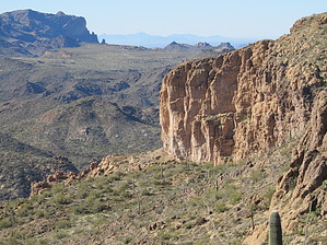
No Trails Necessary by nonot  Overview OverviewPart of a day hike in the midst of a 2-3 day backpacking loop in the central Superstition Mtns. Warning The route is entirely off-trail, and you will encounter plenty of bushwhacking, loose scree, cacti, and all sorts of evil vegetation awaiting you. Due to the ruggedness of terrain, 1 mile/hr is about as good as you can expect unless you are super-Wally.
History The ruins that remain today are but fragments of their former selves. Pot hunters, willing to destroy historical artifacts to sell their ill-gotten booty to collectors and museums, have decimated the sites that were known. Some of them are so lazy as to have left their tools of destruction amongst the shattered remains of these places, in memory of their destruction and idiocy. Hike First: Find yourself a lovely campsite near Charlebois, the Dutchman Trail, or Cavalry Trail. Actual Hike: From Cavalry Trail, find the spot the wash comes down from Squaw Canyon, follow it uphill as best you can. You can elect to stay in the wash or try to find another way. I was unsuccessful in my attempts to find a good way up, although I did find cairns in the creekbed/wash about halfway up. Following these led to impassable walls of thorn-ridden bushes. About 75% of the way up, on the canyon's west side, is an alcove undercut into the massive wall. Traverse over, being careful of the loose scree that will be your nemesis coming back. Within the alcove, you will find several historical artifacts, though the site itself has been destroyed. Searching carefully, you will find the sledgehammer of the vandals who destroyed this fantastic place, rendering it to rubble. Contour east and get around the main wall until you reach the break that forms Squaw Canyon. At this point, you may find cairns directing you up the high, west side of Squaw Canyon until you reach the flat ground up on Peters Mesa. Take a break. You deserve it! Head east, picking the best way through the cactus. If not on, you are near what some refer to as the "Old Military Rd", though I have my doubts about the historical significance of this place. Regardless, it is flat and easygoing. As you near Peters Trail, to your right is the highest peak of the triplet that makes up Black Mtn, once called Charlesbois Mtn. Traverse the saddle to your south and head southeast up the obvious, easygoing slope. Avoid those hidden cacti as best you can, but you may have to break out the tweezers and pliers several times. Once up most of it, the top is an easy grade, and you can walk almost directly south to the peak. I found no summit logs or markers on either of the two small peaks and was unsure which was the true peak 3707. The view from the peak is magnificent, and you can see most, if not all, Superstition landmarks to your west and south. Weavers Needle, Massacre Falls, Superstition Mtn, the Flatiron, Black Mesa, the Praying Hands, Miners Needle, even Apache Junction are all visible. From the peak, head north and slightly east to pick up the Peters Trail, which you take back to your campsite. Water Sources Charlebois spring is considered reliable. LaBarge Creek often has water generally after late winter/early spring rainstorms and only rarely in the fall. It would be best to obtain a water report before heading out on an extended backpacking trip. Camping Ample sites at Charlebois, the Dutchman Trail, or along the Cavalry. Check out the Official Route and Triplogs. Leave No Trace and +Add a Triplog after your hike to support this local community. One-Way Notice This hike is listed as One-Way. When hiking several trails on a single "hike", log it with a generic name that describes the hike. Then link the trails traveled, check out the example. | |||||||||||||||||||||||||||||||||||||||||||||||||||||||||||||||||||||||||||||||||||||||||||||||||||||||||||||||


