 Route Editor

| Guide | ♦ | 54 Triplogs | 2 Topics |
details | drive | permit | forecast | 🔥 route |
stats |
photos | triplogs | topics | location |
| 368 | 54 | 2 |
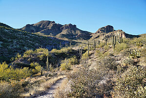
Spur Cross to Go John! by Moovyoaz  When completed, the Maricopa Trail will be a 242-mile loop encircling the county, connecting 9 of 10 MCPR parks. Roughly three years in the making, about 80 miles have been completed as of November 2009. Completion is planned within the next 5 years. Sections of the Arizona Trail and Maricopa Trail on Arizona State Trust land were purchased as perpetual rights of way. Recreation permits are not required on these trails unless you leave the width of the trail. When completed, the Maricopa Trail will be a 242-mile loop encircling the county, connecting 9 of 10 MCPR parks. Roughly three years in the making, about 80 miles have been completed as of November 2009. Completion is planned within the next 5 years. Sections of the Arizona Trail and Maricopa Trail on Arizona State Trust land were purchased as perpetual rights of way. Recreation permits are not required on these trails unless you leave the width of the trail.This hike describes Segments 19, 18, and 17, from the Spur Cross Ranch Conservation Area southwest to Cave Creek Recreation Area. The Spur Cross Trail (Segment 19), one of the earlier fragments of the Maricopa Trail to be completed, was recognized with an Environmental Excellence Award of Merit by Valley Forward. When I hiked it with 15 members of the Friends Hiking Club in April 2010, the area was lush, green, and covered with desert flowers. There is no water along the trail, so bring plenty.
The next 2 miles are fairly level as it follows old dirt roads south and west, offering excellent views of the surrounding areas of Cave Creek and Desert Hills. At this point, the trail turns south for 0.3 miles, jogs right through a cattle guard, then continues south another mile. Here one has the option of turning west on Maricopa Trail Segment 16 for 6 miles to the Anthem trailhead, or east 1.2 miles on Segment 17, which turns south and enters the Cave Creek Recreation Area at the Go John Trail. Continue south on the Go John Trail for 1.3 miles to the CCRA trailhead, for a total of 10 miles. Gate Policy: If a gate is closed upon arrival, leave it closed after you go through. If it is open, leave it open. Leaving a closed gate open may put cattle in danger. Closing an open gate may cut them off from water. Please be respectful, leave gates as found. The exception is signage on the gate directing you otherwise.
Check out the Official Route and Triplogs. Leave No Trace and +Add a Triplog after your hike to support this local community. One-Way Notice This hike is listed as One-Way. When hiking several trails on a single "hike", log it with a generic name that describes the hike. Then link the trails traveled, check out the example. | ||||||||||||||||||||||||||||||||||||||||||||||||||||||||||||||||||||||||||||||||||||||||||||||||||||||||||||||||||||||||||||||||||||||||||||||||||||||||||||||||||||||||||||||||||||||||


