 Route Editor

| Guide | ♦ | 11 Triplogs | 0 Topics |
details | drive | permit | forecast | route |
stats |
photos | triplogs | topics | location |
| 180 | 11 | 0 |
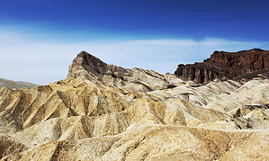
Gold's not the only color by hippiepunkpirate The Golden Canyon Interpretive Trail is a very popular Death Valley hike, but for good reason. Rolling through the brilliantly colored badlands surrounding Zabriskie Point and Manly Beacon, the terrain is incredibly unique. There are more remote places in Death Valley, but there may be none more beautiful. Route Possibilities There are several options for this trail. The statistics above stipulate an out and back from the lower trailhead on Badwater Road up to Zabriskie Point and back the way you came. Also starting at the lower trailhead, it is possible to do a loop of about the same difficulty, which also utilizes the Gower Gulch trail. I have listed this as a separate hike: Golden Canyon - Gower Gulch Loop. The third option is a shuttle, most logically starting at the upper trailhead at Zabriskie Point and ending at the lower trailhead on Badwater Road. According to the Death Valley Trails Illustrated Map, the Golden Canyon Interpretive Trail is 2.3 miles one way. When I did the downhill shuttle in April 2010, I estimated the AEG for the shuttle to be about 200 feet.
If you start at the lower trailhead, grab a pamphlet (this is the interpretive part). There are numbered posts along the trail, so the numbered entries in the pamphlet explain the geology at each stop. Along the initial climb up Golden Canyon, you will notice sections of pavement, with large sections conspicuously missing. That is the power of a flash flood. As the trail comes up out of Golden Canyon, the badlands open up, with Manly Beacon and Red Cathedral towering overhead. There is a short side trail that leads to the base of Red Cathedral, which I didn't explore, but there is a signed junction. The badlands remind me of the Painted Desert in Arizona. The geology is vaguely similar, with ash deposits within the bedrock being the chief cause of the badland topography both here and in the Painted Desert's Chinle Formation. The difference being the Chinle was primarily formed by streams with volcanic ash blown in, whereas the rocks here are the deposits of pre-Basin and Range lakes in which volcanic ash blew in. The volcanic ash in the bedrock creates a clay that creates the classic badland weathering pattern and also makes plant growth impossible. On my hike on the badlands, the only plant life I saw was the gorgeous Panamint Daisies growing in a patch of soil-supporting alluvium. Caves are present at a few places above the trail and are reasonably accessible for exploration. I didn't check them out personally, but a few of my hiking partners did. The temperature inside is noticeably cooler, and one particular cave was about 20 feet deep. Any time of day can be an enjoyable experience at the badlands, but I can personally attest that the nice light in the early morning or late afternoon can enhance the trip immensely. Cautionary Measures For much of this hike, there is no shade to speak of and the sun exposure is intense. I was taken aback by the influence of such exposure during the shuttle. 2.3 miles downhill sounded like a cakewalk to me going in, but I was much more tired than I expected coming out. Part of that was the sun exposure, and part of that was the fact that hiking downhill is more strenuous than we normally think. Bring a hat, bring water, and don't underestimate the extreme climate of Death Valley. This is not necessarily a "hard" hike, but it is harder than it looks on paper, so don't underestimate it or you might find yourself in a dangerous situation. That said...enjoy! Check out the Official Route and Triplogs. Leave No Trace and +Add a Triplog after your hike to support this local community. | ||||||||||||||||||||||||||||||||||||||||||||||||||||||||||||||||||||||||||||||||||||||||||||||||||||||||||||||||||||||||||||||||||||||||||||||||||||||||||||||||||||||||||||||||||||||||||||||||||||


