Route Editor

| Guide | ♦ | 15 Triplogs | 1 Topic |
details | drive | no permit | forecast | 🔥 route |
stats |
photos | triplogs | topic | location |
| 113 | 15 | 1 |
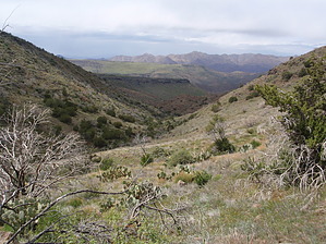
Views & solitude by MEWhiteman   Overview OverviewSeven Springs is a recreation area north of Carefree in the Tonto National Forest. There are over 30 miles of official trails in this area, some connecting to the Spur Cross Recreation Area. This hike called the Inner Loop is a lasso loop utilizing five trails through some beautiful, remote, and hilly country near the Phoenix Metro area. This is a strenuous hike and is difficult to follow in places, but rewards you with great views and solitude. Hike This description of the hike is in the clockwise direction. All trail junctions were signed at the time I did this hike. Begin on the Cave Creek Trail (#4) at the south corner of the parking area (N33 58.344 W111 52.000). Follow #4 for 0.8 miles to the junction with the Cottonwood Creek Trail (#247) (N33 57.833 W111 52.144). There are several side trails along this section, so be careful to stay on #4. At the sign for #247, you want to go left across the river, but at the time I did this the bank was eroded away. There's an easy way down to the river a short distance further on to the left. Once in the riverbed look for cairns leading to one on the opposite bank at N33 57.801 W111 52.131. At this cairn, turn left. The trail makes a sharp right in about .02 miles. From here the trail is easy to follow to the junction with the Skunk Tank Trail (#246) at 1.1 miles (N33 57.617 W111 52.114). You will pass through this intersection on the way back also. At this junction turn left to stay on #247. Continue on #247 for another 2.6 miles to the junction with the Bronco Creek Trail (#245) (N33 55.807 W111 51.386) at 3.7 miles. Bear R here to stay on #247. Continue another 2.1 miles on the Cottonwood Creek Trail crossing Cottonwood Creek numerous times until reaching the signed junction with the Skull Mesa Trail (#248) at mile 5.8 (N33 55.189 W111 53.107).
Turn right on the Skunk Tank Trail (#246). This follows an old road and is easy to follow, unlike the two prior trails. Continue on #246 for 2.8 miles to the junction with the Cottonwood Trail (#247) (N33 57.617 W111 52.114) at 12.9 miles. You passed through this intersection at the beginning of the hike. Turn left onto #247 and retrace your steps from the beginning of the hike. You should be back at the trailhead at 14.0 miles or so depending on how well you were able to stay on the trail and any exploration you did. Check out the Official Route and Triplogs. Leave No Trace and +Add a Triplog after your hike to support this local community. | |||||||||||||||||||||||||||||||||||||||||||||||||||||||||||||||||||||||||||||||||||||||||||||||||||||||||||||||||||||||||||||||||||||||||||||||||||||||||||||||||||||||||||||||||||||||||||||