 Route Editor

| Guide | ♦ | 2 Triplogs | 0 Topics |
details | drive | no permit | forecast | map |
stats |
photos | triplogs | topics | location |
| 8 | 2 | 0 |
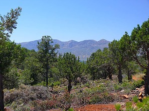
Mazatzal views by Dschur   Overview OverviewPayson Area trails system (PATS) is an in-process interconnecting trail system. They will be using roads, sidewalks, existing forest trails, and roads as well as new trails. There are some of the trails that are outside the city limits of the Town of Payson as well as going thru town. Some of the trails are completed but there are still some that they are working on. Hike The trail starts south of the Event Center. The trail takes off behind a forest service gate with the words "Trail" on it. Here the trail winds all thru the Tapeats sandstone and pinon trees and juniper trees. This is a nice easy hiking area for about the first half-mile. There it meets forest a forest road and you take a right to the west. The road drops down steeply. Here you can see the Mazatzal range for the first time. This part of the road is super rocky and you need to watch your step carefully. This road basically is a trail again, I can't imagine that anyone could drive right here. This continues down past an old miners' house that is only a few walls a couple of feet tall now. There are also old mines in the area too. Then you meet up with another road and follow it along. Here you can tell that there has been vehicle activity and may be busy on the weekends. The road winds along down in a valley to a stand of cottonwoods. There may be areas of water but didn't explore to see. The trail then follows a creek bed and ends up on another road with an easier hike out up a road. This road connects up to the Peach Orchard Trailhead. You may turn around here or have a shuttle back to the parking area. Gate Policy: If a gate is closed upon arrival, leave it closed after you go through. If it is open, leave it open. Leaving a closed gate open may put cattle in danger. Closing an open gate may cut them off from water. Please be respectful, leave gates as found. The exception is signage on the gate directing you otherwise. Check out the Triplogs. Leave No Trace and +Add a Triplog after your hike to support this local community. One-Way Notice This hike is listed as One-Way. When hiking several trails on a single "hike", log it with a generic name that describes the hike. Then link the trails traveled, check out the example. | ||||||||||||||||||||||||||||||||||||||||||||||||||||||||||||||||||||||||||||||||||||||||||


