William Hope and Walter Nordhoff visited this Sierra Ancha site on November 19, 1880, while conducting a mineral assessment of the area for the United States Geological Survey(USGS). The Nordhoff-Hope 1880 mineral survey is also evident from abandoned mining adits dotted along the very scenic FR203A driving route. Dr. Richard C. Lange has continued the legacy with the Sierra Ancha Project starting in 1983 and continuing to the present day.
This short off-trail hike (via a defined use trail)is an interesting side trek to an 800-year-old Salado Cliff Dwelling estimated to have approximately 20 rooms which included its possible interconnecting cliff-cave inner rooms. Due to the very tricky ~25-30 foot sheer cliff climbs required to reach the ledge edge for entrance into these more interesting upper cliff dwellings, this visit will have to leave most with just an imagination of what might reside within...
For this off-trail hike, follow the fence line from the old corral area by working your way downhill along the slope on the obvious but overgrown "use trail" heading west towards the Coon Creek drainage. As you start dropping downhill along this "use trail", a cliff will appear to the right containing this cliff dwelling (at waypoint N33.75372 W110.87736). This is the Nordhoff-Hope Site V:1:170. From the cliff dwelling, you have commanding views of the Coon Creek drainage to the west and south.
When hiking several trails on a single "hike", log it with a generic name that describes the hike. Then link the trails traveled, check out the example.
WARNING! Hiking and outdoor related sports can be dangerous. Be responsible and prepare for the trip. Study the area you are entering and plan accordingly. Dress for the current and unexpected weather changes. Take plenty of water. Never go alone. Make an itinerary with your plan(s), route(s), destination(s) and expected return time. Give your itinerary to trusted family and/or friends.
Permit $$
None
Directions
Road
High Clearance possible when dry
To hike From the Phoenix area:
On Hwy 60 in Globe(MP247.0), take State Hwy 188 northwest toward Lake Roosevelt for 14.7mls to its junction with State Hwy 288(MP229.4); turn Right on State Hwy 288 and drive north for 6.7 miles to signed Cherry Creek Rd(FR203); Turn right(east) on maintained, some washboard, gravel road FR203 and drive for 10.2 miles just past cattle guard to the junction with signed FR203A; Turn left(north) on high clearance FR203A and follow this very scenic-narrow, ridgeline climbing, seldom maintained FR203A for 5.0 miles (to waypoint N33.75378 W110.87177); Park just past the cattle guard at the old corral on the left side of FR203A for this hikes TH Start; Also Note: Parking for the Sierra Ancha "Bull Canyon TH" and the start of Deep Creek TR#128 (see HAZ hike desc- Moody Point Ruins via Deep Creek TR#128) and HAZ- Coon Springs TR#124 are an additional 0.8mi drive further up FR203A;
page created by Grasshopper on May 10 2010 5:40 pm
 Route Editor


 William Hope and Walter Nordhoff visited this Sierra Ancha site on November 19, 1880, while conducting a mineral assessment of the area for the United States Geological Survey(USGS). The Nordhoff-Hope 1880 mineral survey is also evident from abandoned mining adits dotted along the very scenic FR203A driving route. Dr. Richard C. Lange has continued the legacy with the Sierra Ancha Project starting in 1983 and continuing to the present day.
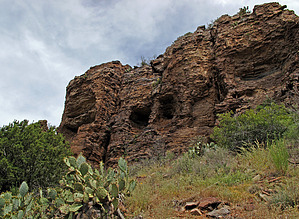


