 Route Editor

| Guide | ♦ | 35 Triplogs | 2 Topics |
details | drive | no permit | forecast | route |
stats |
photos | triplogs | topics | location |
| 387 | 35 | 2 |
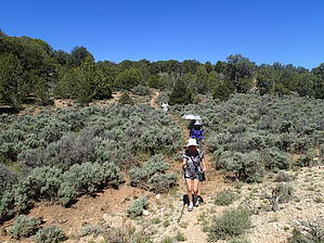
  Hike HikeThis passage begins on Winter Road (BLM Road #1025) about one mile north of the Kaibab National Forest boundary. The route proceeds in a northerly direction and then reaches Dead Man Canyon. After crossing that drainage it continues north and crosses Red Canyon. There is a road crossing and another one a half mile later. After reaching Basin Canyon, the trail switchbacks in and then out of that canyon and crosses another road. The trail crosses an unnamed small canyon and on the top of this canyon, the trail goes through a gate and then does another road crossing. There is a hard turn to the east and then a slight turn to the northeast. After crossing another road, the trail works its way through the upper end of North Larkum Canyon. It parallels this canyon for a while and then comes to the edge of a plateau. The trail executes some 22 switchbacks, working its way down off the plateau, and then crosses sage-covered flats to the Utah border trailhead. Southern Trailhead: Winter Road - BLM road #1025
Gate Policy: If a gate is closed upon arrival, leave it closed after you go through. If it is open, leave it open. Leaving a closed gate open may put cattle in danger. Closing an open gate may cut them off from water. Please be respectful, leave gates as found. The exception is signage on the gate directing you otherwise. Check out the Official Route and Triplogs. Leave No Trace and +Add a Triplog after your hike to support this local community. One-Way Notice This hike is listed as One-Way. When hiking several trails on a single "hike", log it with a generic name that describes the hike. Then link the trails traveled, check out the example. | |||||||||||||||||||||||||||||||||||||||||||||||||||||||||||||||||||||||||||||||||||||||||||||||||||||||||||||||||||||||||||||||||||||||||||||||||||||||||||||||||||||||||||||||||||||


