Route Editor

| Guide | ♦ | 19 Triplogs | 0 Topics |
details | drive | permit | forecast | 🔥 route |
stats |
photos | triplogs | topics | location |
| 229 | 19 | 0 |
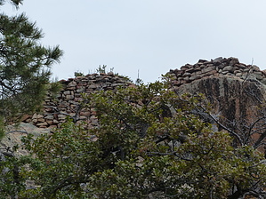
Ancient Views by AZWanderingBear   Overview OverviewThis short trail descends into Oak-Chaparral vegetation, passing through 1.7 million-year-old granites (tan color) to the East Fort fortress ruins. This hike starts on an old 4x4 track, changing to a single track entering the Castle Creek Wilderness. Warning The drive from Crown King to the trailhead is on a seldom maintained dirt road and may be closed during the winter months. A 4-wheel drive is not required, but moderate clearance is.
East Fort is a Hohokam site dating back to approximately 1300 AD. It is one of many hilltop sites that form a network with each site being visible to at least one other. The sites stretch from the northern Phoenix Valley, across the Bradshaws to Prescott and down to Wickenburg. Archaeologists are not certain of the purpose of this extensive network. Hike The trail begins at a sign along the Horse Thief Basin road. From here you can either hike the old jeep trail or park and walk. For those brave enough to drive you will stop either at Castle Creek Wilderness boundary or when you have had enough of the washed-out trail. Most of us will choose the latter option. The jeep trail portion of the hike is a steady descent. The Jeep trail stops near the wilderness boundary marked by a gate. From here the trail climbs steadily. Your objective is right in front of you at this point, but the trail works north up onto the ridge and then south to the Fort. Vegetation includes impressive Manzanita, Alligator Juniper, Ponderosa Pine, and a smattering of wild flowers in season. Deer are plentiful in this area. A few black bears call the southern Bradshaws home as do a very few mountain lions. Upon reaching the summit follow the cairns along the western edge of the rock outcropping around to the fort. Some easy rock scrambling is required. Your dual reward is a small but fairly well-preserved fortress ruin and very impressive views. Take some time and imagine how this would have looked when the Hohokam inhabited this area. If you are still craving some more views after your hike, drive south a short distance along Horse Thief Road to the Horse Thief lookout tower. If the gate is open the tower is manned. Odds are they will invite you up for one of the best views. Most of the watchers are long-time Crown King residents and a chat with them is usually fascinating. Water Sources Water is available at the Ranger Station, Hazlett Hollow Campground, and Turney Group Campground (may be turned off in winter months). Camping Nearby Hazlett Hollow Campground is open from Spring through Fall. Multitudes of dispersed camping sites are available. Gate Policy: If a gate is closed upon arrival, leave it closed after you go through. If it is open, leave it open. Leaving a closed gate open may put cattle in danger. Closing an open gate may cut them off from water. Please be respectful, leave gates as found. The exception is signage on the gate directing you otherwise. Check out the Official Route and Triplogs. Leave No Trace and +Add a Triplog after your hike to support this local community. | |||||||||||||||||||||||||||||||||||||||||||||||||||||||||||||||||||||||||||||||||||||||||||||||||||||||||||||||||||||||||||||||||||||||||||||||||||||||||||||||||||||||||||||||||||||||||||||||||||||||||||