 Route Editor

| Guide | ♦ | 35 Triplogs | 3 Topics |
details | drive | no permit | forecast | 🔥 route |
stats |
photos | triplogs | topics | location |
| 385 | 35 | 3 |
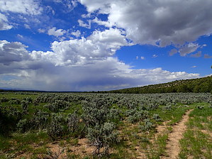
 Throughout this passage, the route follows Trail #101 and it begins at the Orderville Canyon Trailhead on Highway 89A. After crossing the highway the trail curves to the east and then heads north. It parallels FR 249 for a while and then crosses it. The trail heads in a northeast direction until it crosses FR 249 again. From here it heads north again and then begins a descent off of the plateau. It follows a drainage and passes Government Reservoir. It continues descending and heading north-northeast, passing Summit Valley and then leveling out and coming up next to BLM road #1025. This is Winter Road and the passage ends where the trail crosses it. Throughout this passage, the route follows Trail #101 and it begins at the Orderville Canyon Trailhead on Highway 89A. After crossing the highway the trail curves to the east and then heads north. It parallels FR 249 for a while and then crosses it. The trail heads in a northeast direction until it crosses FR 249 again. From here it heads north again and then begins a descent off of the plateau. It follows a drainage and passes Government Reservoir. It continues descending and heading north-northeast, passing Summit Valley and then leveling out and coming up next to BLM road #1025. This is Winter Road and the passage ends where the trail crosses it.Southern Trailhead: Highway 89A - Orderville Canyon TH
Note This page is open to authors. Hike must be listed South to North as one-way. Do not include an overview as the above is permanent. Check out the Official Route and Triplogs. Leave No Trace and +Add a Triplog after your hike to support this local community. One-Way Notice This hike is listed as One-Way. When hiking several trails on a single "hike", log it with a generic name that describes the hike. Then link the trails traveled, check out the example. | ||||||||||||||||||||||||||||||||||||||||||||||||||||||||||||||||||||||||||||||||||||||||||||||||||||||||||||||||||||||||||||||||||||||||||||||||||||||||||||||||||||||||||||||||||||||||||||||


