Kayak
See this triplog for 2015 price to rent a kayak.
Hike
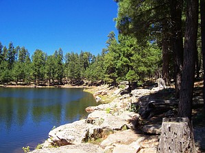
I made this hike with a first-trimester pregnancy (my wife!) and our year and a half baby (27lbs.) in a TREK baby backpack. The week before opening (April 28), the campgrounds were open, and we hiked the entire way around the lake. I'd say that the last two snows and rain last week did some damage to an otherwise relatively easy hike. Parts of the trail were washed away and made for some moderate bouldering/climbing. Not recommended for those with small children, who rarely hike or who don't have four hours or so. There are three or so places where you can find an outhouse along the way. No water or other supplies except at the dock store where you park.
The trail does go completely around the lake and included a few places where we had to cross snowdrift. If you stay near the water or on the clear parts of the trail, you cannot get lost. As the trail follows the lake and its feeder streams, there are a couple of places you have to go a bit of a way up a stream in order to cross and walk back to the lake. Only saw two sets of people once we got beyond the first half-mile. Very beautiful and scenic. About 5.5 miles round trip but seemed longer due to the ups and downs and scrambling. Highly recommended and enjoyable. With all the loose pine needles, etc., and rougher parts of the trail, I'd recommend hiking boots, although my wife did it in cross-trainer tennis shoes with only a bit of slippage.
Hint
Near the dam (to the right of the boat dock), there is a lovely area with small waterfalls to sit (or sit under!) and enjoy the view as well as the cool mist. In the summer, it may have more people, or they may not be letting out water, but it's worth a try, and it's easy to miss if you just skirt the lake and don't follow the outlet till it drops into the meadow below!
WARNING! Hiking and outdoor related sports can be dangerous. Be responsible and prepare for the trip. Study the area you are entering and plan accordingly. Dress for the current and unexpected weather changes. Take plenty of water. Never go alone. Make an itinerary with your plan(s), route(s), destination(s) and expected return time. Give your itinerary to trusted family and/or friends.
Permit $$
None
Directions
Road
Paved - Car Okay
To hike From Payson, take State Highway 260 to Forest Road 300, drive 3 miles on Forest Road 300 to Woods Canyon Lake entrance road. Begin the hike by crossing the dam near Spillway Campground.
 Route Editor

 Overview