Route Editor

| Guide | ♦ | 7 Triplogs | 3 Topics |
details | drive | permit | forecast | map |
stats |
photos | triplogs | topics | location |
| 42 | 7 | 3 |
A pit - but better than by PaleoRob  Warning: Pueblo Pintado ruins are very isolated, despite having a settlement nearby. There is no gas or food available in Pueblo Pintado or Whitehorse. The nearest reliable gas is at Nageezi. In addition, some of the local youth at Pueblo Pintado don't like the Park or tourists. There is extensive vandalism both at the ruins and in Pueblo Pintado. Don't travel alone, lock your car, and don't let it get out of your sight.
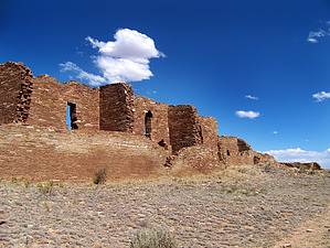
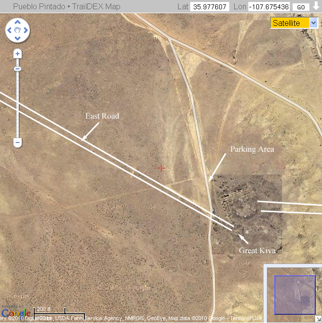
Pueblo Pintado itself was begun in the late 1060's, based on limited tree ring data. By the end of the 1000's, Pueblo Pintado had at least 135 rooms, with up to three stories along the back wall. The north and west walls form a L shape, while the two far points of the L are connected by a curved wall, enclosing a plaza. There is at least one Great Kiva, located southeast of the plaza wall. There is also an addition built onto the southern tip of the core of Pueblo Pintado. Two prehistoric roads ran through the area. The Chaco-Pintado (or East Road) started in Chaco Canyon north of Pueblo Alto and ran east into the west wall of Pueblo Pintado. It can still be seen faintly on the ground, but is one of the best documented roads within the San Juan Basin. It can be traced via aerial photography all the way back to Chaco Canyon. It is especially noticeable when it cuts through ridges. A second road ran to the northeast. This road is almost impossible to detect either on the ground or from aerial photography. Hike: The hike starts from the parking area. You cross through a hiker's maze, where you'll find a visitor log filled with profanity and angry rants from locals, as well as a vandalized sign describing the pueblo and what it may have looked like during the occupation. Heading south along the west wall you will pass a sign that points out the Chacoan road. You can then go into the plaza and explore the room blocks, before heading to the Great Kiva and then back around the northern wall and back to your vehicle. Or go the opposite way - there is no bad way to see the ruin. It is massive even today. Water Sources: None. Bring your own. Camping: Only at Gallo Campground, back in the main portion of Chaco Culture National Historic Park.
Chaco Canyon HP NPS Details NPS PDF Resource Check out the Triplogs. Leave No Trace and +Add a Triplog after your hike to support this local community. | ||||||||||||||||||||||||||||||||||||||||||||||||||||||||||||||||||||||||||||||||||||||