Overview
Horton Springs Trail #292 is the shortest way to hike to Horton Springs. At just over 1 mile in length each direction and close to 1280 feet of elevation loss and then gain on return, the hike to the springs will be steep. The return is the challenge for most hikers as the trail ascends the majority of the escarpment of the Mogollon Rim.
Access
Unless you are incorporating trail #292 into a loop using some of the other trails and roads in this part of the tri-forest area, you will likely access the Horton Springs Trail from FR 300. The trailhead is easy to find as a large brown metal sign indicates where #292 leaves FR 300.
Hike
The hike is very steep descending the rim, but fine for someone who hikes often. At some times the trail is a little braided, but in general, this trail is traveled often enough to have a well-worn path. Numerous cairns also line the entirety of the trail. Overall, I found this to be a pleasant hike through mostly Coconino Sandstone.
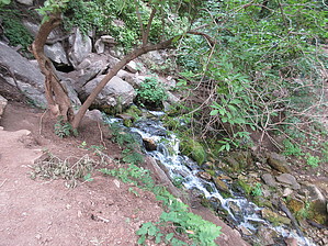
The forest cover thickens as you approach the springs and you begin to encounter some Arizona Walnut and other deciduous trees once above the spring. Follow the cairns around and then through a non-barb wire fence with an obvious opening for hikers and you will see the spring in front of you and slightly below. From here, you connect to several other trails including the ever-popular Highline Trail #31, as well as the Horton Creek Trail #285.
If returning to the Rim or locating #292 from one of the other connecting trails, you will find #292 above and slightly west(left) of the opening for the mouth of Horton Springs. Find the non-barbed wire fence and opening in the fence. Pass through the opening, and turn to the right, locate the cairns. The ascent should be easy to obvious and is marked by a series of cairns for the entire length of the trail. Views open up near the Rim top and are pleasant.
WARNING! Hiking and outdoor related sports can be dangerous. Be responsible and prepare for the trip. Study the area you are entering and plan accordingly. Dress for the current and unexpected weather changes. Take plenty of water. Never go alone. Make an itinerary with your plan(s), route(s), destination(s) and expected return time. Give your itinerary to trusted family and/or friends.
Permit $$
None
Directions
Road
FR / Dirt Road / Gravel - Car Okay
To hike From Payson, AZ, take Arizona Highway 260 east towards and onto the Mogollon Rim. After 260 has gained the Rim and plateau, take FR 300 which is the Rim Road north and west towards the trailhead. The sign coming from Payson will be a green highway sign and for Woods Canyon Lake. The Rim road is also directly across from the Mogollon Rim viewpoint and visitor center. FR 300/ Rim Road is initially paved but turns to a graded dirt surface at the turn off for Woods Canyon Lake. The surface should be passable by all vehicles when the roads are open. Google estimates 30 minutes to cover the 15.3 miles from AZ 260 to the trailhead. It is also possible to take FR 300 from AZ 87, north of Pine.
page created by joebartels on Aug 28 2020 11:11 am
 Route Editor

 Overview