Route Editor

| Guide | ♦ | 12 Triplogs | 2 Topics |
details | drive | no permit | forecast | 🔥 route |
stats |
photos | triplogs | topics | location |
| 142 | 12 | 2 |
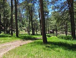
Jump brother jump! by Grasshopper   This is a very pleasant and short loop hike with Parking/TH Start originating off FR139G (0.25mi from the FR139G entrance road/gate to perennial and historic Aspen Spring/Cabin Complex). Hike to and through this entrance gate and down this entrance road 0.25mi to Aspen Spring/Cabin which then connects with Houston Brothers Trail to later "off-trail" the short, easy to navigate distance across Houston Draw to perennial McFarland Spring. This is a very pleasant and short loop hike with Parking/TH Start originating off FR139G (0.25mi from the FR139G entrance road/gate to perennial and historic Aspen Spring/Cabin Complex). Hike to and through this entrance gate and down this entrance road 0.25mi to Aspen Spring/Cabin which then connects with Houston Brothers Trail to later "off-trail" the short, easy to navigate distance across Houston Draw to perennial McFarland Spring.From McFarland Spring this loop hike connects with old logging road FR9616E to later connect with FR139, then up FR139 back to FR139G and 0.5mi up FR139G back to Parking/TH Start. Gate Policy: If a gate is closed upon arrival, leave it closed after you go through. If it is open, leave it open. Leaving a closed gate open may put cattle in danger. Closing an open gate may cut them off from water. Please be respectful, leave gates as found. The exception is signage on the gate directing you otherwise. Check out the Official Route and Triplogs. Leave No Trace and +Add a Triplog after your hike to support this local community. | |||||||||||||||||||||||||||||||||||||||||||||||||||||||||||||||||||||||||||||||||||||||||||||||||||||||||||||||||||||||||||||||||||||||||||||||||||||||||||||||||||||||||||||||||||||||||||||