username
X
password
register
for free!
help
 This is likely a great time to hike this trail!  Check out "Preferred" months below, keep in mind this is an estimate.
  🔥

Kaibab Plateau Central - AZT #41, AZ

Guide 49 Triplogs  2 Topics
  3.3 of 5  
Fav
Wish
2
details
drive
no permit
forecast
🔥
route  
stats
photos
triplogs
topics
location
560 49 2
Statistics
tap row or icons for details
Difficulty 2 of 5
Route Finding 2 of 5
Distance One Way 16.6 miles
Trailhead Elevation 8,850 feet
Elevation Gain -1,322 feet
Accumulated Gain 1,096 feet
Avg Time One Way 7 hours
Kokopelli Seeds 20.25
 Backpack Yes
feature photo
Photos Viewed All MineFollowing
Will recalculate on button tap!
9  2024-01-15
AZT Kaibab Plateau Snowshoe
BiFrost
25  2023-10-26 CannondaleKid
2  2022-09-15 miscbs
29  2021-10-02
North Rim AZT
trekkin_gecko
25  2021-10-02
North Rim AZT
johnlp
48  2019-09-02
Kaibab Plateau Central - AZT #41 north to 205
tibber
25  2019-09-01
Kaibab Plateau AZT 40 to 41 - S to Teleph Hill
tibber
16  2019-08-22 Sredfield
Page 1,  2,  3,  4,  5
Author
author avatar Guides 16,843
Routes 17,472
Photos 24
Trips 1 map ( 6 miles )
Age 28 Male Gender
Location HAZ, TrailDEX
Associated Areas
list map done
Northwest Region
Historical Weather
Trailhead Forecast
Radar Map
Expand Map
Preferred May, Jun, Jul, Sep → 7 AM
Seasons   Late Spring to Early Autumn
Sun  6:02am - 6:53pm
Official Route & 3 Rts
 
8 Alternative
 
Historic Fire Perimetersacres
🔥 2006 Warm WFU41.9 mi*
🔥 2002 Big
🔥 View (All) - over Official Route 🔥
*perimeter length in miles


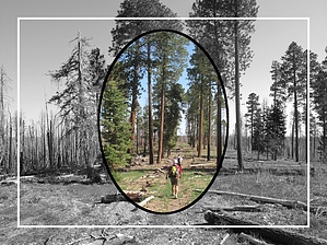
bring a positive attitude for the torched half
by HAZ_Hikebot

 Likely In-Season!
Overview
Throughout this passage, the route follows Trail #101 and it begins at the Telephone Hill Trailhead on FR 241. From here it heads generally north and parallels Highway 67. The trail reaches a drainage and crosses it, and at the top of the drainage a road is crossed and then the trail continues in a north/northeast direction. The trail crosses FR 205 twice and then crosses FR 205B. It runs next to FR 225 for a while and then begins a long gradual descent. It follows a drainage down to Big Ridge Tank, and after a short climb, the trail continues descending until it reaches the Orderville Canyon Trailhead and Highway 89A.


Southern Trailhead: Telephone Hill TH - FR 241
remove free decal offer
Northern Trailhead: Highway 89A - Orderville Canyon TH

Note
This page is open to authors. Hike must be listed South to North as one-way. Do not include an overview as the above is permanent.

2018-07-14 HAZ_Hikebot


    Check out the Official Route and Triplogs.
    Leave No Trace and +Add a Triplog after your hike to support this local community.

    One-Way Notice
    This hike is listed as One-Way.

    When hiking several trails on a single "hike", log it with a generic name that describes the hike. Then link the trails traveled, check out the example.
    WARNING! Hiking and outdoor related sports can be dangerous. Be responsible and prepare for the trip. Study the area you are entering and plan accordingly. Dress for the current and unexpected weather changes. Take plenty of water. Never go alone. Make an itinerary with your plan(s), route(s), destination(s) and expected return time. Give your itinerary to trusted family and/or friends.

     Permit $$
    None


     Directions
    or
     Road
    TBD

    To hike
    page created by joebartels on May 06 2008 6:41 pm
     90+° 8am - 6pm kills
    helpcorrectionissue

    end of page marker