Route Editor

| Guide | ♦ | 20 Triplogs | 0 Topics |
details | drive | permit | forecast | route |
stats |
photos | triplogs | topics | location |
| 89 | 20 | 0 |
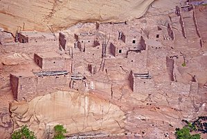
Ancestral Puebloans by PaleoRob  Overview OverviewThe Sandal Trail is a relatively easy trail that leads from the Visitor's Center at Navajo National Monument to an overlook of Betatakin (or Talastima in Hopi). This is the most common way that people get to experience these ruins. Warning There is little shade along the trail, and it is exposed so that during a summer monsoon, you will want to use caution when hiking.
Betatakin ruins were occupied beginning around 1267 and abandoned less than 25 years later, around 1286. Its original inhabitants were what archaeologists now call the Kayenta Anasazi or the Ancestral Puebloans. The Hopi call these people the Hisatsinom, which essentially means The Old People or Our Ancestors. The Hopis have several stories about why their ancestors left the area, including a preordained migration, being chased out by a giant snake, and being driven out by others. Archaeologists would agree with them being driven out, to some extent, but would also add drought, famine, and changes in weather patterns. While Navajos say that they have always been in the Tsegi Canyon, archaeologists say that Navajos did not move into the Tsegi area until the time of the Long Walk, when Kit Carson's troops were driving on Canyon de Chelly to take the Navajos into captivity at Bosque Redondo. Navajo oral tradition also states that the ancient Navajos lived side by side with the Hisatsinom and trace several of their clans back to times with the Anasazi in the Tsegi system. Navajo National Monument was declared by President Taft in 1909, with John Wetherill named the first caretaker. Despite this, Betatakin was not discovered until after the monument was declared, when Wetherill was guided to the site by local Navajo Clatsozen Benully. It was first excavated by Neil Judd in 1917 and extensively dated by Jeffrey Dean in the 1960s. Today it is only accessible via a guided tour, but anyone can hike the easy Sandal Trail to the overlook point and be awed by the view into Betatakin Canyon. Hike The hike starts behind the Visitor's Center and passes through some displays of the Navajo history of the area. The trail then bends and follows the canyon rim, passing by metal signs that display information about the local plant life and how Navajos and the Anasazi could have used the various flora to their benefit. The trail is paved and descends slowly, with one final switchback takes you down to the observation platform, where there is a viewing scope and a shade roof. After you have seen all you wanted, return to the trailhead via the same route. Water Sources Only at the Visitor's Center. Camping Camping is available within the monument at two campgrounds but not along the Sandal Trail itself. Check out the Official Route and Triplogs. Leave No Trace and +Add a Triplog after your hike to support this local community. | ||||||||||||||||||||||||||||||||||||||||||||||||||||||||||||||||||||||||||||||||||||||||