Route Editor

| Guide | ♦ | 19 Triplogs | 0 Topics |
details | drive | permit | forecast | route |
stats |
photos | triplogs | topics | location |
| 187 | 19 | 0 |
Canyons are inherently risky. Flash floods occur without notice on sunny days. Technical skills & surrounding topography knowledge required yet does not eliminate risk.
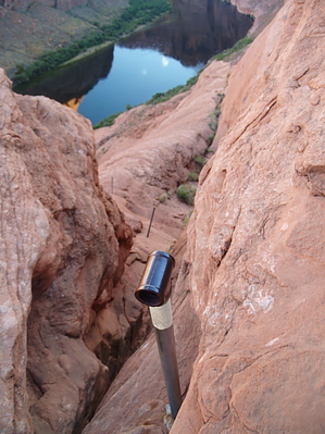
Don't lose your lifeline! by PaleoRob   Overview OverviewThe Rope Trail provides one of the few ways to access lower Glen Canyon from the rim below Glen Canyon Dam. The trail is steep in the extreme and requires the use of cables to navigate successfully. Kayakers occasionally use it to haul their boats down to the Colorado River. Warning Warnings cannot be overemphasized on this trail. You are dropping 700 feet down to the river via an almost sheer cliff. The access is by joints and cracks in the Navajo Sandstone, and steel cables are the only way to regain the rim. Be aware of the extreme exposure, the lack of potable water, shade along the route, and the strenuous nature of the hike/climb out of the canyon. The bottom of the canyon will consistently be warmer/hotter than the rim. In addition to these dangers, there are also weather-related dangers - thunderstorms that sweep the area in the summertime can present lightning and flash flood dangers. This route is recommended for experienced hikers only! If you have any doubts about this route, do not attempt it! If you ask the Park Service at the Carl Hayden Visitor Center about this hike, they will do everything in their power to dissuade you from taking this route. Take safety seriously with this hike.
The Ropes Trail exploits only a handful of natural routes to the Colorado River between Lee's Ferry and Glen Canyon Dam. When it came into existence and why are subject to discussion and debate. However, with no authoritative answers to be found. Hike While hikers were in former times able to take the old radio tower road (and some renegades still attempt to), I cannot encourage this. If you do chance it, you risk an encounter with a Bureau of Reclamation security guard. This means a slightly longer hike unless you are willing to forge around in deep sand with your truck. From the parking area just off of US89, descend into the wash between two sandstone ridges, trending southwest. The eastern ridge will be topped with transmission towers. After clearing the end of both ridges, head southeast. The route down to the river will start in a depression underneath a set of power lines. As you approach the rim, you will notice a series of metal poles with eyelet-type fixtures on the top. These mark the way to the river. The upper sections of the Ropes Trail has had the cable removed, so you will have to scramble down/up this section without aid unless you string your own rope. You will have to descend through a joint in the rock (again following the poles) and then a slickrock bulge before reaching the river. Some consider the last section of the trail to be the most strenuous portion of the trail. You will need the cable to help you back up this stretch, though perhaps not for the descent, depending on your skill level. The trail ends at The Ropes Campsite, one of the dedicated places to camp within lower Glen Canyon and a pretty spot. You can pack down your camping gear, but remember that unless you hitch a ride with a boat, you'll have to pack it back out too. Water Sources The Colorado River flows cold and clear at the bottom of Glen Canyon year-round, but pack in all your water unless you want to drink the river. Camping Possible at the base of the trail, at the designated campsite. Otherwise, all other portions of the trail are day-use only. Check out the Official Route and Triplogs. Leave No Trace and +Add a Triplog after your canyon trip to support this local community. | ||||||||||||||||||||||||||||||||||||||||||||||||||||||||||||||||||||||||||||||||||||||||||||||||||||||||||||||||||||||||||||||||||||||||||||||||||||||||||||||||||||||||||||||||||||||||||||