 Route Editor

| Guide | ♦ | 24 Triplogs | 1 Topic |
details | drive | permit | forecast | route |
stats |
photos | triplogs | topic | location |
| 464 | 24 | 1 |
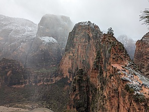
Better than Angel's Landing by KingLeonidas  Logistics/Getting There: The West Rim Trail goes from upper Zion Canyon all the way to Lava Point in the Kolob Canyon Area. Doing the whole length involves either an arduous day hike or backpacking, arranging a shuttle, and getting a wilderness permit. If you are starting from the bottom, take the shuttle to the grotto (shuttle stop #6), cross the river, and the hike starts from there. From the top, you would start from Lava Point and hike down into Zion from there (exiting via the shuttle). Note: Lava point is often closed in the winter due to snow, this was the case for us and limited us to the bottom-up day hike.
The Grotto Trailhead offers restrooms and water-filling stations. Navigation: The West Rim Trail is a well-defined but strenuous route. From the Grotto shuttle stop #6, cross the Virgin River and follow the trail towards Scout Lookout/Angels Landing. After Refrigerator Canyon and Walters Wiggles, you will arrive at Scout Lookout. This is where the Angel's Landing spur trail is, turning left will keep you on the West Rim trail. Weather: Zion National Park experiences hot summers and cool winters. Spring (March-May) and fall (September-November) are ideal times for the West Rim Trail, offering comfortable hiking temperatures. Summer heat can be brutal on this exposed trail, so start very early and bring plenty of water. Be aware of potential flash flood dangers during monsoon season and anytime there is significant precipitation. We actually had a winter storm roll in when we hiked it in Late March/Early April which forced us to turn back before reaching Cabin Spring (our intended destination) but snow this late in the year is rare. Trail Conditions: What starts as a paved trail begins its ascent through a series of switchbacks, offering stunning views of the canyon below. After Scout Lookout, the trail is mostly rock including some slickrock (although most of the stone is more grippy sandstone). With the few inches of snow on the ground we had, even the sandstone was slippery. This portion of the trail is very steep and has lots of switchbacks. After Cabin Spring the elevation gain moderates, and the terrain becomes a forested plateau. None of the trail is technical but trekking poles will help with the snow if you didn't bring crampons. General Comments and Musings: The West Rim trail encompasses the majority of the Angel's Landing hike (only the last spur is permit only) and continues to ascend to further viewpoints that are overlooking and more impressive than Angel's Landing. Despite this, the vast majority of people on the trail stop and Angel's Landing and do not venture further, missing out on the best part of the hike! We intended to go all the way to Cabin Spring, but the winter storm was dropping significant volumes of snow to the point that trekking poles alone were no longer cutting. Even sandstone will eventually become slickrock if you put enough snow and ice on it. The descent was phenomenal with the snow and sun occasionally peeking through the clouds providing incredible views. We stopped frequently on the descent to take photos. I can see the appeal of the full 16-mile top-down thru-hike. This was a beautiful hike and a real gem of Zion.
Check out the Official Route and Triplogs. Leave No Trace and +Add a Triplog after your hike to support this local community. One-Way Notice This hike is listed as One-Way. When hiking several trails on a single "hike", log it with a generic name that describes the hike. Then link the trails traveled, check out the example. | |||||||||||||||||||||||||||||||||||||||||||||||||||||||||||||||||||||||||||||||||||||||||||||||||||||||||||||||||||||||||||||||||||||||||||||||||||||||||||||||||||||||||||||||||


