 Route Editor

| Guide | ♦ | 1 Triplog | 0 Topics |
details | drive | no permit | forecast | map |
stats |
photos | triplog | topics | location |
| 13 | 1 | 0 |
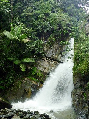
Big Trees Big Falls! by chumley Hike: The hike begins at a parking area along PR-191 about 4.5 miles past the visitor center (at marker 10.4km). Park here and get ready for your hike. If you are planning on swimming, you may wish to wear quick-drying swimwear as there are no changing facilities on the trail. Additionally, I highly recommend water shoes or tevas if you plan on exploring the river or pools as the bottom is uneven and rocky. Tevas are perfectly suitable for this hike as the trail is paved concrete the entire way.
Despite the overall elevation loss from the trailhead to the falls, this trail has its fair share of ups and downs, including some short steep parts, and some sections with steps. Footing is easy however along the narrow 18" concrete path that keeps your feet off the muddy and wet rainforest floor. In the first 1/4 mile of the trail, numerous signs inform you about the various plants and trees, describes the rainforest ecosystem, climate, and how hurricanes and landslides help rejuvenate the forest. Taking the time to read all the signs will lengthen your trip a bit, but if its not raining, its a pretty nice place to take it slow. Eventually the signs become scarce and the trail winds its way up and down, and around a couple of ridges and through a small river drainage. The second time you hear the sound of running water, you are nearing the steep and powerful La Mina River and La Mina Falls. Take the time to enjoy the water, take some photos and/or explore the area. You can return to the trailhead by retracing your path back, or alternately continue hiking upstream on the La Mina Trail, which parallels the river upstream for about 0.7 mile. The La Mina Trail is a more difficult trail, climbing nearly 500 feet but is very popular because of its proximity to the La Mina River and the numerous small falls and swimming holes along its length. If you choose to go this way, you will arrive at the Palo Colorado visitor center on PR-191, one mile uphill from the trailhead where you parked. You can hike down the road or return the way you came if you did not pre-arrange a car shuttle with somebody you know. Caution:Its a RAIN forest. It WILL RAIN. It IS WET. ALL the time. You will be wet. Your stuff will get wet. Even if you don't go swimming. Be prepared. Plan ahead. As stated above, if you plan on being in the water, appropriate footwear is strongly recommended. There are no changing facilities and there's always a chance of theft of unsupervised property, so be aware. Always lock valuables in your trunk at the trailhead. Common sense... Warning: Flash Floods are common along this river drainage. As with Arizona hiking, flash flooding can occur when rain falls far upstream, so you must be aware of rising water at all times! Check out the Triplog. Leave No Trace and +Add a Triplog after your hike to support this local community. One-Way Notice This hike is listed as One-Way. When hiking several trails on a single "hike", log it with a generic name that describes the hike. Then link the trails traveled, check out the example. | |||||||||||||||||||||||||||||||||||||||||||||||||||||||||||||||||||||||||||||||||||


