Route Editor

| Guide | ♦ | 1 Triplog | 0 Topics |
details | drive | permit | forecast | route |
stats |
photos | triplog | topics | location |
| 27 | 1 | 0 |
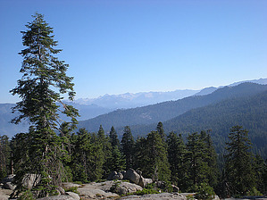
Georgeous Views! by paulhubbard The trailhead is easy to find, well signed just off the General's Highway in Sequoia National Park. From the trailhead you make your way up a gentle incline for about a mile, affording you ever increasingly panoramic views of the Kings Canyon area to the east, and the valleys around Fresno to the west. The trail is very well defined and meanders through trees and open areas with HUGE rock formations. When you approach the rock "peak" the trail seems to kind of just vanish, but not to fear; Just look and go UP. It's very easy to scramble up to the top of the rock summit, and once at the top the 360 degree views are hard to beat.
This is a great short hike, one that should not be skipped because it's "too easy." Take a picnic lunch, take your time, take your camera, and enjoy the peaceful solitude. Check out the Official Route and Triplog. Leave No Trace and +Add a Triplog after your hike to support this local community. | ||||||||||||||||||||||||||||||||||||||||||||||||||||||||||||||||||||||||||||||||||||||||||||||||