Overview
There are at least three(3) hiking options to summit New Mexico's highest peak- Wheeler Peak at 13,161 feet.
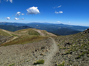
The FIRST hiking option is an out and back via the Bull of the Woods TH-Wheeler Peak TR#90 (see posted HAZ hike description for details). This SECOND option described here (a recommended "Shuttle Hike"), "starts" at the upper Williams Lake TH-TR#62 and "ends" at the Bull of the Woods TH-Wheeler Peak TR#90 lower start location.
It is this authors personal opinion that this SECOND option shuttle hike provides more diverse and scenic hiking enjoyment with less repetitive trails and approximately four(4)less hiking miles with ~1000 feet less AEG than the out and back FIRST hiking option described above. It should also be noted that this SECOND hiking option does require some Class 2 on some upper sections of the "unofficial" use trail that is utilized to hike from the beginning east end of Williams Lake (at way point N36.55775 W105.42998) to connect near the summit with upper Wheeler Peak TR#90 (at way point N36.55907 W105.41556).
This hiking route summits three peaks between TH Start and TH End: Wheeler Peak at 13,161 feet; Mount Walker at 13,133 feet; Mount Frasier at 12,163 feet;
WARNING! Hiking and outdoor related sports can be dangerous. Be responsible and prepare for the trip. Study the area you are entering and plan accordingly. Dress for the current and unexpected weather changes. Take plenty of water. Never go alone. Make an itinerary with your plan(s), route(s), destination(s) and expected return time. Give your itinerary to trusted family and/or friends.
Permit $$
None
Directions
Road
FR / Jeep Road - Car possible when dry
To hike From the center of Taos, NM: Drive 4 miles north on NM 64 to the junction of NM 150 and NM64. Turn right onto NM150 and drive 15 winding road miles up to the upper parking lot of Taos Ski village. After the large welcoming sign on the left, turn into the large upper parking lot and follow it approx .3ml past this upper lot area to the Bull of the Woods Trail Head parking, which is the most active Wheeler Peak Trail#90 TH Start on the left side, just behind the wilderness information sign (Note: you are now at way point N36.59668 W105.44969);PARK SHUTTLE VEHICLE#1 HERE; From this #1 parking and way point location TRANSFER TO SHUTTLE VEHICLE#2 and "drive/follow the posted driving route" for 1.9 miles to end at the upper TH Parking and Trail Start for Williams Lake TR#62 (at way point N36.57938 W105.44003);
page created by Grasshopper on Aug 30 2010 10:26 pm
 Route Editor