Route Editor

| Guide | ♦ | 7 Triplogs | 0 Topics |
details | drive | permit | forecast | 🔥 route |
stats |
photos | triplogs | topics | location |
| 134 | 7 | 0 |
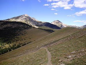
got sheep by BrettVet The Pecos baldy trail is well traveled because of the spectacular high mountain scenery , wild life , flowers . Once you get about 2 miles from the trailhead you regain your solitude even on weekends. The reason it is crowded is that it is so spectacular.
The trail #25 leaves directly across from the parking area and starts heading up. The first 1000 feet of elevation takes place in the first mile of the trail. The trail then levels out through ponderosa pine forest and breaks out into a high mountain meadow with the first critical junction. Trail #25 continues on to Beatty's cabin and Trail 257 heads to Pecos Baldy Lake. The reason this junction is critical is that the Pecos Baldy trail doubles back and a lot of people see Pecos Baldy Peak ahead of them and miss the turn. Take a minute to look across the Pecos River valley to the east. Hamilton Mesa which is the grassy area directly across the valley. Trail #257 immediately goes into a massive aspen grove and then breaks into another meadow frequented by elk and grazing cattle. In July and August the meadows are covered with a blanket of wildflowers. The trail crosses a couple of bogs the enters the woods again and drops into the Jack's Creek drainage at mile marker 4.0 . When you cross jacks creek GO RIGHT and stay on trail 257. Another trail intersects hear and the signage is poor. The trail begins the last climb to the lake which is in a basin below the peak. Just before the trail enters the lake basin the Skyline Trail #251 crosses. The Skyline Trail follows the ridgeline of the Santa Barbara Divide in a wide arc around the Pecos river drainage. To the right is mostly above the tree line. There are a lot good campsites to the right and left along this trail that are flat with water. There is no camping by the lake. The clear mountain lake with Pecos Baldy peak as a backdrop is stunning. This lake has a resident herd of Bighorn Sheep that are beyond friendly and can be pests around the campsites. Sometimes they are on the ridgeline high above the lake to the north. It is worth packing binoculars. I have heard conflicting reports about fish in the lake. Several fly fishermen were complaining about no fish but one old-timer swears he catches trout with worms. The lake is a great first night backpack and can be part of a bigger loop to Truchas lake , Beatty's cabin and beyond. Check out the Official Route and Triplogs. Leave No Trace and +Add a Triplog after your hike to support this local community. | ||||||||||||||||||||||||||||||||||||||||||||||||||||||||||||||||||||||||||||||||||||||||||||||||||||||