|
| | | |
| |
|
| Hiking | 45.00 Miles |
2,000 AEG |
| | Hiking | 45.00 Miles | 3 Hrs | | 15.00 mph |
| 2,000 ft AEG | | | | |
|
|
| |
| Linked |
|
none
[ show ]
| no linked trail guides |
| Partners |
|
none
[ show ]
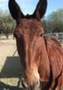
| no partners | | My friend and I have been planning this trip for years. We both loved camping and backpacking, but unfortunately the AARP membership also included bad knees and a hip that will not allow much hiking over a few miles. Riding mules is my answer to getting into the back country. I also sense a little animosity toward riders from the hiking community, so I am a little hesitant to post here. I hope that I share with you the love of the trail as much on the back of my mule as I did hiking and backpacking. I just hope that when I need Oxygen my mule won't be spooked by the hissing sound.
Anyhow, we tried packing in everything but the kitchen sink to one spot and riding out from there and that involved way too much work. I decided that I would use my backpacking skills to design a lightweight progressive pack trip that involved a pack mule taking the stuff in my backpack. .,.,O.K. I had to include a full size folding chair because it makes camping out so much nicer. The rest was basic backpack gear plus a saw and shovel. I will get to those later.
We had planned to do a 50 miler, but plans change and we ended up doing 45 miles. The first night was to be at Pecos Baldy Lake, but because it was labor day weekend (crowded) and our mules were hot to trot we made it there in record time. We averaged 4 miles per hour, so we made it there in 2 hours and decide to go on to Tuchas Lake another 5 miles away. We climbed on to TrailRiders wall and rode down the spine of the mountain range. The views were magnificent and it was a good choice because we did not see a soul. Truchas Lake is a much prettier lake and we found a great campsite just beyond the lake. From here we climbed the Santa Barbara divide and followed another ridgeline to a mountaintop. Here we lost the trail and decided to take another route down because our choice was to follow the GPS along the blowing mountain ridgeline or drop into a pine forest and make our way to Pecos Falls. We decided the latter. One of the advantages of mules in the backcountry is that we keep trails from overgrowing and we pack a saw and clear trail of downed trees as we go. There were lots of downed trees after wew left the ridgeline as it looked like nobody had been on the trail for years. Once you get 20 miles from the trailhead, trail maintenance is a little sparse.
We camped below Pecos Falls( which is over rated as a waterfall) and ran into a young couple that was beyond lost. They asked how far it was to Pecos Baldy Lake from here and I had to tell them we had just come over 2 mountain ranges and no, you could not get there from here. I gave them my map, told them where to camp near Pecos falls and planned out the rest of there backpack trip . They had missed the first turn that had sent them in completely the wrong direction and it was too late to recover. We spent two nights here and did a day ride back up the ridgeline we were supposed to cross through meadows with herds of elk. . The next day we rode out through Betty's meadow with more spectacular scenery.
This is one of the more spectacular backpacks in the country with scenery, water and solitude. To blow my own horn a little, we cleared trail in the middle of nowhere and helped people salvage there backpack trip. . It does not get any better than this. |
| _____________________
| | |
|
|
|
 Route Editor