Route Editor

| Guide | ♦ | 2 Triplogs | 0 Topics |
details | drive | no permit | forecast | route |
stats |
photos | triplogs | topics | location |
| 9 | 2 | 0 |
Short steep climb in the western part of Tilden by JimmyLyding There are basically 4 trails in this loop. The northernmost portion is the Big Springs Trail which quickly but moderately ascends the northern flank of a small tributary canyon of Wildcat Creek. The portion along the Bay Area Ridge Trail is flat near its intersection with Big Springs, but gains 200 feet at the base of Vollmer Peak. The upper part of the hike is on the steep, paved Seaview Trail. The Lupine Trail on the south leg of the loop is very steep and loose.
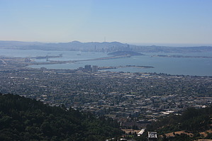
The Bay Area Ridge Trail heads out flat from the junction, and quickly begins to climb as it nears Vollmer Peak. The vegetation along the trail is similar to that along Big Springs, but the eucalyptus is replaced by a thick woodland consisting of a number of oak species. The Seaview Trail is very steep, and also paved. The entire Seaview Trail is .75 mile long, but you only need it for about a quarter mile. Vollmer Peak itself is flat and open with a good variety of electronic gear. There are extensive views east towards Orinda and the Diablo Valley, to the south of Moraga and the Oakland Hills, and west to the entire central portion of San Francisco Bay. The city, Alcatraz, and the Golden Gate are clearly visible. The Lupine Trail heads downhill off of the Seaview Trail just uphill from the Bay Area Ridge Trail. It travels the same amount of elevation as the Big Springs Trail, but in only 3/4 the distance. It is quite steep, and the footing is treacherous. In contrast to the other side of the canyon, this area is coated in a thick manzanita scrub forest. The chaparral disappears as you reach the bottom of the canyon in a deep forest of thick eucalyptus groves, tall pines, and the occasional huge oak. You will need to walk along South Park Drive to the right (north) for .10 mile to return to the trailhead.
Check out the Official Route and Triplogs. Leave No Trace and +Add a Triplog after your hike to support this local community. | |||||||||||||||||||||||||||||||||||||||||||||||||||||||||||||||||||||||||||||||