Route Editor

| Guide | ♦ | 14 Triplogs | 1 Topic |
details | drive | no permit | forecast | route |
stats |
photos | triplogs | topic | location |
| 213 | 14 | 1 |
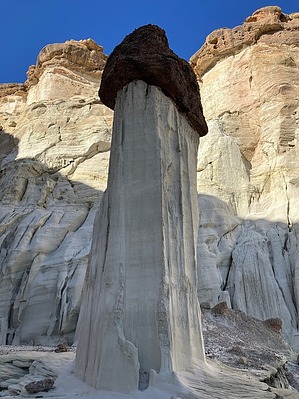
Brave the boredom to hang with the hoodoos by John10s  The Wahweap Hoodoos are located north of Highway 89 between Page, AZ, and Kanab, UT. These unique geological features formed over millions of years through differential erosion; the softer Entrada Sandstone that forms the light-colored pillars eroded more quickly, leaving the tall spires that support the darker, slower-eroding Dakota Sandstone capstones. This reddish rock layer was once part of an ancient, Cretaceous-era beach. The hoodoos can be accessed via a flat, easy hike of ~4.5 miles down Wahweap Creek wash to a side canyon full of these unique geological features. Hiking the wash isn't particularly interesting, but the longer hike is one of the reasons this impressive site doesn't draw the same level of crowds as Toadstool Hoodoos farther west along 89.
From the signed Wahweap Trailhead parking lot, start walking north, where you'll immediately see a pair of "Trail" signs pointing toward the wide, flat wash. These are the only signs marking the trail, but route finding isn't an issue since the wash leads to the hoodoos. Early on, a use trail follows the east side of the wash and passes through a fence after about a quarter mile. Depending on the season and the amount of water or mud in the wash, it may be easier to hike on the banks in some places or simply hike in the wash. The posted route provides a guideline, but there's no correct trail or specific route to follow, and you'll likely see footprints scattered around different parts of the wash and on the banks. As long as you continue to generally follow the wash to the north, you're on the right track. Some intriguing side canyons come into view farther up Wahweap Creek--check out the triplogs for more information about some of these potential add-ons. Around three miles in, the first hoodoos will start to become visible ahead on the west side of the canyon. Farther ahead, the geology of the cliff walls becomes more interesting and varied, and the white cliffs have a layer of darker sandstone on top, indicative of what you'll see when you reach the hoodoos. As you approach the side canyon on the west, about four miles up the wash, thicker brush blocks the entrance, but a use trail hugs the west canyon wall to provide a more direct route through/around the brush. From there, turn into the side canyon to get your first unobstructed views the impressive geology of the Wahweap Hoodoos, the scenic reward for a comparatively dull hike to reach this spot. Multiple use-trails weave around the bases of the tall spires; take your time and explore amongst the pillars, and see the unique erosion on the canyon walls. The cliffs provide shade early and late in the day, making this a nice spot for a break. If you continue farther west into the canyon, the hoodoos start to disappear, but the geology remains interesting, and there's a deep alcove in the back of the canyon. If you're up for a little more exploration, the next canyon to the north has another cluster of hoodoos, including some of the tallest in the area. When you're ready to go, you can return to the parking area via the same route, following Wahweap Creek wash to the south. Check out the Official Route and Triplogs. Leave No Trace and +Add a Triplog after your hike to support this local community. | ||||||||||||||||||||||||||||||||||||||||||||||||||||||||||||||||||||||||||||||