username
X
password
register
for free!
help
  🔥

Haigler Creek via Fishermans Point, AZ

Guide 24 Triplogs  0 Topics
  4 of 5  
Fav
Wish
8
details
drive
no permit
forecast
🔥
route  
stats
photos
triplogs
topics
location
204 24 0
Statistics
tap row or icons for details
Difficulty 1.5 of 5
Route Finding 1 of 5
Distance Round Trip 1 mile
Trailhead Elevation 5,909 feet
Elevation Gain -330 feet
Accumulated Gain 350 feet
Avg Time Round Trip 1 hour
Kokopelli Seeds 2.75
 Interest Perennial Creek
 Backpack Possible - Not Popular
feature photo
Photos Viewed All MineFollowing
14  2023-07-09
Haigler Creek to Colcord Canyon
mikemcg
10  2021-05-09
Colcord
jillyonanadventu
6  2019-03-22
Haigler Headwaters / Naegelin
MountainMatt
8  2018-09-28 OdinWiski
9  2017-10-14
Naegelin / Upper Haigler
MountainMatt
15  2017-10-10
Colcord Fall via Hagler Creek
topohiker
15  2017-09-30
Colcord Fall via Hagler Creek
topohiker
5  2017-09-23 topohiker
Page 1,  2,  3
Author
author avatar Guides 170
Routes 148
Photos 5,914
Trips 2,097 map ( 11,156 miles )
Age 48 Male Gender
Location Tucson, AZ
Associated Areas
list map done
Payson Region
Historical Weather
Trailhead Forecast
Radar Map
Expand Map
Preferred Apr, Oct, May, Mar
Seasons   Early Spring to Early Winter
Sun  5:59am - 6:46pm
Official Route & 2 Rts
 
1 Alternative
 
Historic Fire Perimeteracres
🔥 Haigler 20077.1 mi*


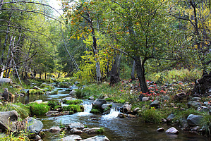
If you're going to Young...
by PrestonSands

Overview
This hike follows a closed jeep trail down to scenic Haigler Creek, a perennial creek in the forested hills between Young and the Mogollon Rim. One can hike to the creek and back for a short little adventure or continue as far up Haigler Creek canyon as desired for a more extended trip.


Hike
Once you have located Fishermans Point with its seemingly out-of-place guard rail (a parking barrier in reality) and interpretive sign, park your vehicle and begin your hike. The trail to the creek follows a closed jeep trail that departs from behind the left (north) side of the guard rail. The descent along the old jeep trail is quite steep, and trekking poles come in handy. Tall ponderosa pines provide ample shade along the way. Partway down, the jeep trail makes a switchback, while a distinct trail continues off from the switchback point. It does not matter whether you take the trail or the jeep trail from this point, as both routes meet up just before the creek.
remove free decal offer
After a three hundred-foot descent in a half of a mile, you will arrive at the rushing waters of Haigler Creek. The canyon bottom here is decorated with pines, alders, sycamores, and Virginia Creeper vines. The water is refreshing and downright chilly even in summer, and a few small pools are just big enough to soak in. This area sees frequent use by the weekend party crowd from my experiences, so I wouldn't advise camping here, but it is certainly worth a day visit. A few ATV riders have managed to sneak around the guard rail at the top and have made it down to Haigler Creek, despite the "closed to motor vehicles" sign at the top.

From the end of the jeep trail at Haigler Creek, one can walk a short distance down the canyon to a rocky area with some small cascades. Going up the canyon, one enters an attractive canyon of tall pines and high mountainsides once you have bypassed a rocky ridge at the upper end of the 5600-foot contour.

2010-10-19 PrestonSands


    Check out the Official Route and Triplogs.
    Leave No Trace and +Add a Triplog after your hike to support this local community.
    WARNING! Hiking and outdoor related sports can be dangerous. Be responsible and prepare for the trip. Study the area you are entering and plan accordingly. Dress for the current and unexpected weather changes. Take plenty of water. Never go alone. Make an itinerary with your plan(s), route(s), destination(s) and expected return time. Give your itinerary to trusted family and/or friends.

     Permit $$
    None


     Directions
    or
     Road
    FR / Dirt Road / Gravel - Car Okay

    To hike
    From Payson drive east on Highway 260 for approximately 24 miles. Turn right at the sign for Colcord road (aka FR 291) and follow this road (which turns to dirt after about 2 miles) for 4.2 miles to FR200. Turn right on FR200 (Chamberlain Trail) and drive for 5.3 miles to a parking pullout on the left, on a sharp curve to the right. A guard rail and a Forest Service sign for "Fishermans Point" marks the site.
    page created by PrestonSands on Oct 19 2010 10:04 pm
     90+° 8am - 6pm kills
    helpcorrectionissue

    end of page marker