ride around water gushing out of willows by HAZ_Hikebot
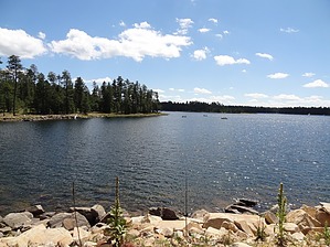
This trail loops from the Larson Ridge Trailhead (vault toilet) or the Horse Trap Trailhead, traveling through cool pines and quaking aspen. The western section of the trail parallels the shoreline of Willow Springs Lake.
(Apache-Sitgreaves National Forest info)
The trail is an old, closed road with minimal elevation change that appears to be well marked. It connects with Sardine Trail? and the General Crook Trail #140.
WARNING! Hiking and outdoor related sports can be dangerous. Be responsible and prepare for the trip. Study the area you are entering and plan accordingly. Dress for the current and unexpected weather changes. Take plenty of water. Never go alone. Make an itinerary with your plan(s), route(s), destination(s) and expected return time. Give your itinerary to trusted family and/or friends.
Permit $$
None
Directions
Road
Paved - Car Okay
To hike From the Highway 87/Highway 260 junction in Payson, drive east for about 32.6 miles on highway 260, to milepost 284.7, directly across the highway from the Young Road (FR 512) turnoff. There is a sign on the north side of the highway for Horse Trap Trailhead and a small parking area. The signed trail begins here and reaches the main loop in a few hundred yards.
page created by PrestonSands on Oct 22 2010 11:10 pm
 Route Editor

 This trail loops from the Larson Ridge Trailhead (vault toilet) or the Horse Trap Trailhead, traveling through cool pines and quaking aspen. The western section of the trail parallels the shoreline of Willow Springs Lake.