 Route Editor

| Guide | ♦ | 145 Triplogs | 2 Topics |
details | drive | no permit | forecast | 🔥 route |
stats |
photos | triplogs | topics | location |
| 1.6k | 145 | 2 |
Rim Views, Aspens and Meadows - V 55.5 - V113 by The_Eagle  Overview OverviewThis historic trail currently starts in the high desert of 5000’, approximately 20 miles east of its original start at Ft Whipple in Prescott. It passes through the site of Ft Verde before climbing to the Mogollon Rim’s tall pines at almost 8000’. Its current eastern terminus at the Cottonwood Wash TH is 145 miles and 10,750’ in Accumulated Elevation Gain, from its start. The trail spans Prescott, Coconino, and Apache-Sitgreaves. National Forests (Trails #64, #130, #140). The original western start at Ft Whipple (now the Prescott VA Hospital area) to its current start around P20, is not established or marked, but the general path is known. The original eastern portion of this trail from V113 to Ft Apache is a little less known and may have used numerous routes.
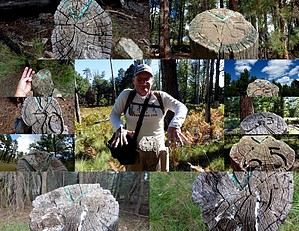
The Trail was developed as a supply route to Ft. Apache from Fort Whipple in Prescott. The scouting for the trail was started in 1871 with General Crook and a small party leaving Ft Apache heading north, and then traversing the rim to the west, arriving at Ft Whipple on September 6th. Actual trail construction began in spring 1872 from Ft Whipple (Prescott) and the Show Low area, both heading towards Ft Verde. By 1873 the first pack train with supplies made the trip from Ft Whipple to Fort Apache. One year later, the first wagon trains made the journey. For 22 years, the trail was used by Crook’s men to patrol the northern border of the Apache Reservation. Infrequent Civilian use continued for another 24 years until the Rim Road was built in 1929. This trail was designated as the state’s first Arizona State Historic Trail. The trail was marked for distances from Ft Verde. Markers to the west of Fort Verde were indicated with a “P” (for the Prescott side) and the Miles from Ft Verde (i.e., P7 was 7 miles west of Ft Verde). On the east side, markers were indicated with a “V”. V20 distinguishes 20 miles from Ft Verde on the way to Ft Apache. Distances back then were derived from counting the number rotations of a wagon wheel. Only a few of the original blazes remain. The best example is possibly 13-mile rock, (V13), which can be seen at the pullout on route 260 on the way up the rim. Reestablishment of the Trail The Grand Canyon Council Boy Scouts of America, Troop 26, re-traced and re-marked the current trail. They did this for their Bicentennial Project starting in 1976. In the western/lower elevations, they marked the trail with rocks in wire baskets and Mileage markers on 4” x 4” posts. As of this description, many of the posts remain, but none of the mileage signs have survived. Once in the higher elevations where trees are present, the trail's location is indicated with white or red metal “V’s” attached to trees of posts. Mileage markers are placed on 6” diameter posts approx. 4’ tall. Mileage is etched into the slanted top of this post (i.e., V 21) Warning The Boy Scouts did a great job back in 1976, hiking and marking this trail as part of their Bi-Centennial project. Without this effort, it would not have been possible for us to hike it. The trail is a bit hard to follow in spots. Some spots are marked better than others. If you haven’t seen a “V” chevron on a tree for a while, turn around and check the backside of the trees and also check on some of the fallen trees. A GPS with a loaded track is an essential tool on this trail. Additional Reference Material “A Guide to the General Crook Trail” Published by the Museum of Northern Arizona Press and the Boy Scouts of America Copyright 1978 Hardcopy purchased online “General Crook National Historic Study Trail – Study Report” USDA Forest Service SW Region Sept 1986 Found on the internet Water Availability See Spring Reports Additional Trail Segments The remainder of the current General Crook Trail is made up of the following Trail descriptions. Please see one of the following Guides and GPS Tracks for the remainder of the trails. P21 – V0 (Ft Verde) General Crook Trail #64 - Prescott NF, AZ V0 (Ft Verde) – V55.5 General Crook Trail #130 - Coconino NF, AZ Hike Now in Apache Sitgreaves National Forest, and still winding through forests, you’ll pass by Promontory Tree V63 (actually located at V62). The Promontory Lookout Tower is a short walk off the trail located on the Rim Road. At V64-1/2, you pass a large sinkhole, a couple of hundred yards around and about 80' deep, aptly named “Hole-in-the-Ground.” Some of the best undisturbed General Crook roadbed can be found between V68 and V70, most notable around V70. At approx. V71 (Marker not found), the trail crosses the FR300 and shortly thereafter SR260. We followed the Beige “V” markers here for the original trail, but Red “V” markers support a more recent reroute. On the south end of Lake #1 at approx. V72, you pass up the third Grave. This is the grave of Al Fulton - Shot 1901. His killing seems to be related to the Pleasant Valley wars. The trail continues to wind through the pines and aspens, crossing back over SR260 and routes through the Forrest Lakes neighborhood before ultimately crossing south back over SR260 to V80. Another large sinkhole, Jacob's Well, is located around 75-3/4. Between V80 and Nelson Lake at V81-1/2, pay close attention to the markers or your GPS. The trail is a bit thin in spots here. Nelson Lake appears to be a popular campsite, as was evidenced by the Elk Hunters using the area as we hiked through. From V82 past Gentry Lookout at V85-1/2 to V95-1/2, the trail plays tag with and more or less follows FR300. If you have some time and want to check out the next set of graves, take a ½ mile one-way side trip down the Hangmans Trail #500. This trail is located just east of the Black Canyon Rim Campground (approx. V83-1/2) and will lead you to a small Cemetery. The Cemetery contains the gravesites for Jamie Stott, Jim Scott, and Billy Wilson. Three men lynched by vigilantes on Aug 4 1888, during the Pleasant Valley Feud. At approximately V90, we also stumbled upon a much more modern grave, with a metal tube cross marker. All that was on it was the Initials “CTP”. Through this area, keep an eye out for wild horses. We spotted five on our hike through this area. Phoenix Park is the next destination and is located around V99. This area was first used as a grazing area for cattle in 1873 by George Stinson of Phoenix. This is an expansive open meadow area that was used to camp and to provide the first real grass feed for the Wagon team’s Stock on the trip up the trail. On the north end of the meadow are the ruins of the Daniel Boone Holcomb Homestead. The chimney for the old homestead still stands. The original General Crook Trail used to go through the Williams Ranch area. It has since been re-routed to the North at approx. V111. The Williams Ranch area has a 10' tall Elk fence around it. There are quite a few buildings scattered across all the acreage. This is one of the oldest ranches in the area. At Approximately V113 you will finish the current General Crook at the Cottonwood TH. As of this description, there was no indication whatsoever that this was the General Crook Trail, nor all or any of the history surrounding the trail. Check out the Official Route and Triplogs. Leave No Trace and +Add a Triplog after your hike to support this local community. One-Way Notice This hike is listed as One-Way. When hiking several trails on a single "hike", log it with a generic name that describes the hike. Then link the trails traveled, check out the example. | ||||||||||||||||||||||||||||||||||||||||||||||||||||||||||||||||||||||||||||||||||||||||||||||||||||||||||||||||||||||||||||||||||||||||||||||||||||||||||||||||||||||||||||||||||||||||||||||||||||||||||||||||||||||||||||||||||||||||


