username
X
password
register
for free!
help


Cactus, AZ

Guide 7 Triplogs  0 Topics
  2 of 5  
Fav
Wish
0
details
drive
no permit
forecast
map
stats
photos
triplogs
topics
location
11 7 0
Statistics
tap row or icons for details
Difficulty 1 of 5
Distance One Way 1.3 miles
Trailhead Elevation 2,056 feet
Elevation Gain 205 feet
Accumulated Gain 233 feet
Kokopelli Seeds 2.08
 Interest Seasonal Creek
feature photo
Photos Viewed All MineFollowing
4  2020-11-10
Bulldog Canyon Loop
AZLOT69
31  2012-04-20
Dome Mountain 3381 - Goldfield Mtns
outdoor_lover
31  2011-12-24
Dome Mountain 3381 - Goldfield Mtns
jochal
10  2011-02-28
Dome Mountain 3381 - Goldfield Mtns
Charger55
26  2010-11-15
Three Lesser Peaks Trail
AZLOT69
11  2010-10-23 AZLOT69
Author
author avatar Guides 16,843
Routes 17,472
Photos 24
Trips 1 map ( 6 miles )
Age 28 Male Gender
Location HAZ, TrailDEX
Associated Areas
list map done
Phoenix Region
Historical Weather
Trailhead Forecast
Expand Map
Preferred Jan, Dec, Feb, Nov
Sun  6:02am - 6:48pm
2 Routes
 
0 Alternative


remove free decal offer

 
Guide Needed
Publish Full Detail Guide


Use +Add above to share photos and triplogs
Overview: Trail is an old jeep trail and a major access into the Goldfields.
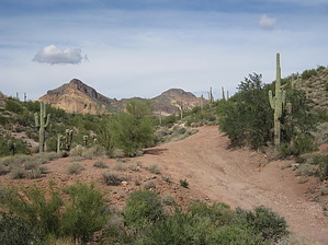
Happy

Trails!


    Check out the Triplogs.
    Leave No Trace and +Add a Triplog after your hike to support this local community.

    One-Way Notice
    This hike is listed as One-Way.

    When hiking several trails on a single "hike", log it with a generic name that describes the hike. Then link the trails traveled, check out the example.
    WARNING! Hiking and outdoor related sports can be dangerous. Be responsible and prepare for the trip. Study the area you are entering and plan accordingly. Dress for the current and unexpected weather changes. Take plenty of water. Never go alone. Make an itinerary with your plan(s), route(s), destination(s) and expected return time. Give your itinerary to trusted family and/or friends.

     Permit $$
    None


     Directions
    or
     Road
    FR / Dirt Road / Gravel - Car Okay

    To Bulldog Canyon Gate Trailhead
    From US60
    Highway 60 to Apache Junction exit Idaho north to McKellips, turn right on McKellips and go one-half mile to Wolverine and turn left to Tonto drive. Right on Tonto Drive(pavement ends) to Cactus, Left turn on Cactus (north), east on McDowell, and follow it to the trailhead where FS 10 is blocked by a locked iron gate.

    From Loop 202 & Brown: 8.9 mi / about 16 mins
    1. Head east on E Brown Rd toward N 86th St ○ 3.9 mi
    2. Turn left onto N Meridian Dr ○ 1.0 mi
    3. Turn right onto W McKellips Blvd ○ 2.5 mi
    4. Turn left onto N Wolverine Pass Rd ○ 0.9 mi
    5. Turn right onto E Tonto St ○ 0.2 mi
    6. Turn left onto N Cactus Rd ○ 0.1 mi
    7. N Cactus Rd turns right and becomes E McDowell Blvd ○ 387 ft
    8. E McDowell Blvd turns left and becomes N Cactus Rd ○ 0.1 mi
    5300-5498 N Cactus Rd, Apache Junction, AZ 85119

    If you plan ahead, you may drive the Bulldog Canyon OHV (off-highway vehicle), there's an admin fee, and you will need a 4x4 vehicle for many sections of the road.

    Information on the Bulldog canyon OHV permit

    From PHX (I-10 & AZ-51) - 41 min (38.9 miles)
    From TUC (Jct 1-10 & Grant) - 1 hr 52 min (103 miles)
    From FLG (Jct I-17 & I-40) - 2 hr 39 min (179 miles)
    page created by AZLOT69 on Oct 23 2010 2:45 pm
     90+° 8am - 6pm kills
    helpcorrectionissue

    end of page marker