 Route Editor

| Guide | ♦ | 39 Triplogs | 0 Topics |
details | drive | no permit | forecast | route |
stats |
photos | triplogs | topics | location |
| 337 | 39 | 0 |
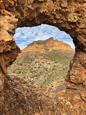
Did the Lone Ranger model his after this one? by sventre  2020 Note 2020 NoteFormerly "The Mask". Now dubbed Cyclops as the fragile arch is history. Hike Most hikers would probably approach this "dual arch" from some point along FR 10. As the forest road proceeds through Bulldog Canyon, "the Mask" becomes readily accessible. I chose a different access route beginning at the Idaho Road TH.
As you continue through the wash the walls become narrow and higher. If you are fortunate the granite confines of the wash may produce a variety of desert creatures for your enjoyment. You may wish to continue through the wash for its entirety until you connect with Bulldog Canyon, or at various points, you can exit the wash to the east and connect up with one of the horse trails also heading in your direction. Once you connect with Bulldog Canyon (shortly after you pass by a water collection tank) you will head east, climbing over the seasonal waterfalls and rocks. When the water is flowing this spot is a "grotto in the desert". Continue east along the watercourse of the canyon being vigilant for the point between Peak 2249 and Peak 2299 where the arch comes into view. The Mask is on the saddle immediately west of Peak 2299 (your left, north) but not readily discernible until you have passed slightly beyond an imaginary perpendicular line drawn directly south of its location. The GPS coordinates are 33.48604N, 111.54868W. The climb from the base of the canyon to the Mask is a bushwhack across loose rocky terrain, but I was fortunate enough to intersect a game trail that provided reasonably stable footing and a more or less direct line to the arch. The Mask is not very large and looks as though it might be susceptible to crumbling in the not-too-distant future, but it is one of the more easily accessible arches in the Goldfield Mountains. Gate Policy: If a gate is closed upon arrival, leave it closed after you go through. If it is open, leave it open. Leaving a closed gate open may put cattle in danger. Closing an open gate may cut them off from water. Please be respectful, leave gates as found. The exception is signage on the gate directing you otherwise. Check out the Official Route and Triplogs. Leave No Trace and +Add a Triplog after your hike to support this local community. One-Way Notice This hike is listed as One-Way. When hiking several trails on a single "hike", log it with a generic name that describes the hike. Then link the trails traveled, check out the example. | ||||||||||||||||||||||||||||||||||||||||||||||||||||||||||||||||||||||||||||||||||||||||||||||||||||||||||||||||||||||||||||||||||||||||||||||||||||||||||||||||||||||||||||||||||||||


