Overview
This exciting Goldfield bushwhack passes over a variety of interesting terrain, bags three Goldfield Peaks, takes in a couple natural arches, passes by a hidden valley on its way to major washes leading to the junction with the Packsaddle Trail. This trail is best combined with one of several optional trails to make it a shuttle, key exchange, loop or extended backpack.
When hiking several trails on a single "hike", log it with a generic name that describes the hike. Then link the trails traveled, check out the example.
WARNING! Hiking and outdoor related sports can be dangerous. Be responsible and prepare for the trip. Study the area you are entering and plan accordingly. Dress for the current and unexpected weather changes. Take plenty of water. Never go alone. Make an itinerary with your plan(s), route(s), destination(s) and expected return time. Give your itinerary to trusted family and/or friends.
Permit $$
Information is listed below
Directions
Road
FR / Dirt Road / Gravel - Car Okay
To hike This trail starts where the cactus trail ends. From Apache Junction, north on Idaho Road to McKellips. Right on McKellips to Wolverine Pass, left on Wolverine Pass to Tonto drive. Right on Tonto Drive(pavement ends) to Cactus (sign hard to read), Left turn on Cactus (north), east on McDowell and follow it to the trailhead where FS 10 is blocked by a locked iron gate. This Trail is part of the Bull Dog Canyon OHV area and an administrative permit can be obtained at no cost from the Mesa Tonto Forest Office. The permit will allow further access beyond the gate for those with a four wheel drive vehicle and you could actually park at the Three Lesser Peaks Trailhead.
 Route Editor

 Overview
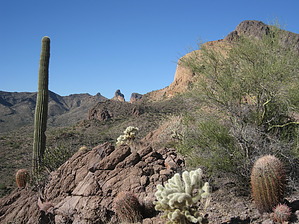


