Route Editor

| Guide | ♦ | 33 Triplogs | 0 Topics |
details | drive | no permit | forecast | route |
stats |
photos | triplogs | topics | location |
| 174 | 33 | 0 |
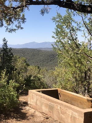
Beautiful trees and a stunning ridgeline by Forbesy   I started the hike at around 1300, and the sun was still peeking through the beautiful oak and alligator juniper trees. The trail is a slight uphill grade until you meet up with the Arizona Trail #31, with an overall elevation gain of about 700 feet. The manzanita is beautiful this time of year; the red bark offset by the intense green foliage. The oaks are changing colors as well, from green to yellow and some full-on red. There are numerous points along the trail which open up to beautiful views of the entire forest. I started the hike at around 1300, and the sun was still peeking through the beautiful oak and alligator juniper trees. The trail is a slight uphill grade until you meet up with the Arizona Trail #31, with an overall elevation gain of about 700 feet. The manzanita is beautiful this time of year; the red bark offset by the intense green foliage. The oaks are changing colors as well, from green to yellow and some full-on red. There are numerous points along the trail which open up to beautiful views of the entire forest.I went up on a clear day and could see for miles and miles. When you reach the actual Red Rock Spring, you have to search for it a bit, as it bubbles up, then goes underground for a ways. There wasn't any water, so make sure and pack plenty for your adventure. I didn't see much animal life, only a few tracks of what I suspect were mountain lion. There were no other hikers/campers, so I had the trail all to myself. It was amazingly quiet, with the wind wisping through the trees. The huge red rocks spilt all around the trail; along the path, the fallen rocks paint a landscape of many different brilliant hues of red. This trail was a perfect day-hike excursion for me and my dog. Enjoy :) Check out the Official Route and Triplogs. Leave No Trace and +Add a Triplog after your hike to support this local community. | |||||||||||||||||||||||||||||||||||||||||||||||||||||||||||||||||||||||||||||||||||||||||||||||||||||||||||||||||||||||||||||||||||||||||||||||||||||||||||||||||||||||||||||||||||||||||||||||