Overview
Very remote and interesting eastern Superstition Wilderness "connector" Trail #213 hike beginning on a 2.5-mile hike section of Upper Horrell Creek then connecting (at the historic Mormon Corral) onto the remaining 2.31-mile hike section of decommissioned Pinto Peak Trail #213 and ending at an intersection of Campaign Trail #256.
When hiking several trails on a single "hike", log it with a generic name that describes the hike. Then link the trails traveled, check out the example.
WARNING! Hiking and outdoor related sports can be dangerous. Be responsible and prepare for the trip. Study the area you are entering and plan accordingly. Dress for the current and unexpected weather changes. Take plenty of water. Never go alone. Make an itinerary with your plan(s), route(s), destination(s) and expected return time. Give your itinerary to trusted family and/or friends.
Permit $$
None
Directions
Road
Strictly 4x4
To Horrell Trailhead From Hwy60/FR287-Pinto Mine Road, continue thru the Pinto Mine area on FR287 continuing north on FR287 to the historic Horrell Ranch area at FR287/FR305. Turn left(west) onto 4WD only FR305 and proceed on this sometimes difficult to follow FR305 to the trailhead.
Please Note: It is highly recommended to review, download, then upload in a GPS Receiver, the GPS Route Drive to THs for TR276 and TR213.
From PHX (I-10 & AZ-51) - 84.8 mi, 1 hour 44 mins ( add a good half hour to all times... slow road ) From TUC (Jct 1-10 & Grant) - 119 mi, 2 hours 30 mins From FLG (Jct I-17 & I-40) - 228 mi, 3 hours 46 mins
 Route Editor

 Overview
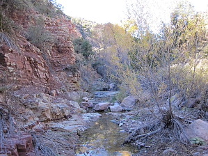


