Route Editor

| Guide | ♦ | 29 Triplogs | 0 Topics |
details | drive | no permit | forecast | route |
stats |
photos | triplogs | topics | location |
| 333 | 29 | 0 |
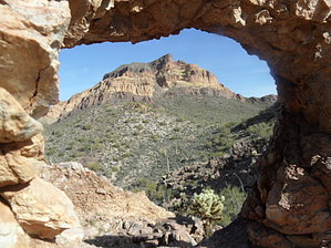
spying landmarks at lunch by bensondk  My description will assume that if you are planning to do this hike, you would be using a downloaded GPS track, or will be printing the GPS track and carrying that with you. Because so much of the route does not involve a trail, the GPS track is only a guide for where to go, if you are not able to find a better route. The track does help find the small arches that are among the highlights of the trek. My description will assume that if you are planning to do this hike, you would be using a downloaded GPS track, or will be printing the GPS track and carrying that with you. Because so much of the route does not involve a trail, the GPS track is only a guide for where to go, if you are not able to find a better route. The track does help find the small arches that are among the highlights of the trek.The loop starts from the Dome Mountain trailhead, beyond which you would need a permit to pass through the gate with motorized vehicles. For the first part of the hike, walking is easy and follows either a road or creek bed. This part of the trail will be in common with the return part of the trip. The trail will split at a point where a couple of old TV sets have been abandoned and shot up a bit with a shotgun. Is this a dump? About 0.4 miles from here, we ascended a small hill to have a look around, and just enjoy the views.
We followed the road for about 1.3 miles, and as the road crossed a creek bed, we traveled about 100 yards up the creek, then turned up a smaller creek to ascent to the south and towards Dome Mountain. Although there are a few cairns, there is no real trail up the creek, so you will need to pick your way along between the boulders, and vegetation. This is a long stretch of the trail and goes up to the high saddle between the peak of Dome Mountain, and an adjacent peak of only about 100 feet lower. Once we were at the saddle, we had lunch, and most of us decided we were too close to the top to not finish, so we hike the adjacent peak, and then finished with a trip to the peak of Dome Mountain. Both peaks have great views of the surrounding area. We happened to be there at a time when the fountain at Fountain Hills was running, so it was pretty visible. It was interesting to pick out the landmarks that we could easily recognize such as Weaver's Needle, and the Superstition Ridgeline, and then hunt for harder-to-see landmarks such as Battleship Mountain. When we looked at the return trail, we considered different options, but in the end, traveled down the south side, on a slope that is fairly steep to start with, but finishes more gradually, before meeting a jeep trail that leads back toward the trailhead. Gate Policy: If a gate is closed upon arrival, leave it closed after you go through. If it is open, leave it open. Leaving a closed gate open may put cattle in danger. Closing an open gate may cut them off from water. Please be respectful, leave gates as found. The exception is signage on the gate directing you otherwise. Check out the Official Route and Triplogs. Leave No Trace and +Add a Triplog after your hike to support this local community. | ||||||||||||||||||||||||||||||||||||||||||||||||||||||||||||||||||||||||||||||||||||||||||||||||||||||||||||||||||||||||||||||||||||||||||||||||||||||||||||||||||||||||||||||