username
X
password
register
for free!
help


Ma Ha Tuak Trail, AZ

Guide 130 Triplogs  1 Topic
  2.4 of 5  
Fav
Wish
0
details
drive
no permit
forecast
route  
stats
photos
triplogs
topic
location
194 130 1
Statistics
tap row or icons for details
Difficulty 1.5 of 5
Distance One Way 1.2 miles
Trailhead Elevation 1,346 feet
Elevation Gain 393 feet
Accumulated Gain 450 feet
Kokopelli Seeds 2.7
feature photo
Photos Viewed All MineFollowing
Will recalculate on button tap!
6  2025-07-09 mt98dew
10  2025-03-19
North South Loop
chumley
5  2025-01-01 mt98dew
7  2024-03-31 david_allen_3
8  2024-02-21
Hau Pal-Alta-Ma HaTuak loop
The_Eagle
4  2023-11-04
Maricopa Peak
trekkin_gecko
3  2023-11-04
Maricopa Peak
johnlp
8  2021-08-14 david_allen_3
Page 1,  2,  3,  4
Author
author avatar Guides 16,843
Routes 17,472
Photos 24
Trips 1 map ( 6 miles )
Age 28 Male Gender
Location HAZ, TrailDEX
Associated Areas
list map done
Phoenix Region
Historical Weather
Trailhead Forecast
Radar Map
Expand Map
Preferred Mar, Feb, Nov, Dec
Sun  6:05am - 6:49pm
Official Route & 2 Rts
 
18 Alternative


remove free decal offer

 
Guide Needed
Publish Full Detail Guide


Use +Add above to share photos and triplogs


Happy

Trails!


  • 2022 South Mountain Park
    area related
    2022 South Mountain Park


Check out the Official Route and Triplogs.
Leave No Trace and +Add a Triplog after your hike to support this local community.

One-Way Notice
This hike is listed as One-Way.

When hiking several trails on a single "hike", log it with a generic name that describes the hike. Then link the trails traveled, check out the example.
WARNING! Hiking and outdoor related sports can be dangerous. Be responsible and prepare for the trip. Study the area you are entering and plan accordingly. Dress for the current and unexpected weather changes. Take plenty of water. Never go alone. Make an itinerary with your plan(s), route(s), destination(s) and expected return time. Give your itinerary to trusted family and/or friends.

 Permit $$
None


 Directions
or
 Road
Paved - Car Okay

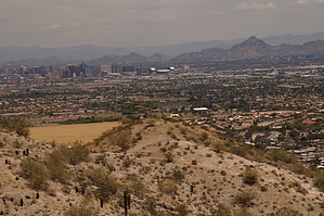
To 19th Ave Trailhead
From Phoenix, take 19th Ave south to where it dead-ends at the trailhead parking lot at the base of the mountain. The gate generally opens at 05:00 am. Do not leave valuables in your vehicle.

From PHX (I-10 & AZ-51) - 24 min (11.3 miles)
From TUC (Jct 1-10 & Grant) - 1 hr 44 min (110 miles)
From FLG (Jct I-17 & I-40) - 2 hr 14 min (148 miles)
page created by joebartels on Jan 02 2011 12:06 am
 90+° 8am - 6pm kills
helpcorrectionissue

end of page marker