 Route Editor

| Guide | ♦ | 1 Triplog | 1 Topic |
details | drive | no permit | forecast | route |
stats |
photos | triplog | topic | location |
| 10 | 1 | 1 |
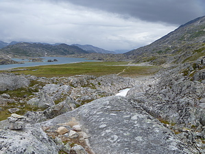
footsteps of the stampeders by HAZ_Hikebot The Chilkoot Trail is one of two main routes to the Klondike that originate in this area. Long before the gold rush, the trail was established by Tlingit people as a trade route into the interior of Canada. Fish, seal oil, and seaweed were traded with the First Nations peoples for moose and caribou hides, plant materials, and other goods unavailable on the coast. The most challenging way to follow in the footsteps of the stampeders and natives is by hiking the 33-mile-long Chilkoot Trail, accessible only on foot. It is a difficult hike and usually takes three to five days. The trail begins at the Taiya River bridge near the Dyea townsite and travels over the Chilkoot Pass to Lake Bennett.
There are a total of nine designated and maintained campgrounds on the Chilkoot Trail: • Finnegan's Point Finnegan's Point is located next to the Taiya River, while the valley is still relatively flat. The mosquitoes are horrible at Finnegan's Point partly due to its location and the abundance of standing water. The campsite itself features a canvas warming and cooking shelter complete with mosquito screens, a bear pole, and a bear-proof food storage locker for safekeeping of food overnight, an outhouse, and ample tent sites. • Canyon City Canyon City is the second-largest campground on the American side of the trail. It, too, is conveniently located right next to a small tributary of the Taiya River. It features a spacious log cabin complete with a wood stove, numerous shelves full of artifacts, several bunks (although sleeping is not permitted inside park shelters), and several shelves for cooking. It also has a small porch ideal for hanging up gear to air out or dry and some wooden chairs to sit in. Canyon City features over 30 campsites and two outhouses, as well as food lockers and bear poles. • Pleasant Camp Pleasant Camp is the smallest campground on the American side of the trail. It is located next to a sandbar in the Taiya River. It features a warming and cooking shelter, a spattering of campsites, and a bear pole. Pleasant Camp usually serves as a backup campground in case Sheep Camp is full. There is a sign near the cooking shelter notifying backpackers whether Sheep Camp is at capacity or can still take backpackers. • Sheep Camp Sheep Camp is the largest of the American campsites. It is located between a crick of meltwater from the adjacent mountains and some branches of the Taiya River. Occasionally after disruptions upstream such as avalanches, rockslides, or exceptional rains, portions of Sheep Camp next to the Taiya become flooded. Sheep Camp has three separate canvas shelters, a small cache used by the trail crew, outhouses, and over 40 campsites. The only U.S. Ranger Station on the trail is located just a few hundred meters north of Sheep Camp and the ranger, during the official season, comes down to give a presentation on the history and current conditions of the pass. • Happy Camp Happy Camp is the only campground on the trail entirely out of the treeline, although small shrubs are prevalent. A tiny wooden warming cabin and a food closet, as well as an outhouse (with refuse deposited into a container that is heli-lifted out to protect the fragile alpine environment), are all located at this campsite. There are a decent amount of campsites, but the number is limited due to the rather steady slope. However, in the spring, watching the melt-off streams pour into the small river in front of Happy Camp can be a spectacular sight. • Deep Lake Deep Lake is the only one of two campgrounds to be devoid of protective shelter and is one of the smallest on the trail. Deep Lake has an outside cooking area, bear-proof lockers for food, and a small number of campsites. However, views from here are spectacular. It is situated between the end of Long Lake and the beginning of Deep Lake, both of which hold a most mysterious indigo hue. • Lake Lindeman This is the largest campground on the Canadian side and possibly the entire trail. Featuring separate north and south campsites, a small cluster of buildings for the wardens and trail crew, a makeshift dock and boat for transportation of the wardens (unlike the Americans, the Canadian wardens cannot just hike out to Skagway), a canvas shelter containing a museum of photographs and a small library on the outdoors and Klondike history, and a web of trails leading through the remains of the old town. The north and south campsites each feature a large wooden cabin that serves as a cooking and warming shelter, numerous bear poles, and several picnic tables. The campsites are located throughout the surrounding sparse pine forest and are never far from the lake. • Bare Loon Lake Bare Loon Lake is the other campground on the trail without a warming shelter, though it now sports a pavilion-style cooking shelter. Located on a small ridge above Lake Lindeman in a spacious pine forest and overlooking the small Bare Loon Lake, the campground is one of the most beautiful on the trail. There is an outhouse, a helicopter pad, and bear poles. One can also swim in the lake. Unlike almost every other water source encountered on the trail thus far, Bare Loon Lake is not glacially fed, and so, while it may be cold, it does not compare with the newly-melted water that feeds the Taiya River, Deep Lake, or Lake Lindeman. • Bennett Bennett is the end of the trail and the first step back into civilization. There are several structures built and maintained by the White Pass and Yukon Route, including a museum for tourists, a depot, and housing for employees. There is also a private First Nations residence that is off-limits and private property. While Bennett doesn't have a shelter specific for cooking, there is shelter to be found easily among the structures scattered throughout Bennett. The campground is relatively small and has bear poles, picnic tables, and an outhouse. Also at Bennett is the still-standing St. Andrew's Presbyterian Church. It is a remnant from the gold rush and has since been renovated. Warning: While in the summer there are full-time rangers and wardens on both the U.S. and Canadian sides, the Chilkoot Trail is still by no means without its risks. Bears Bears are the primary concern in the park. It is very common for hikers to encounter them. Firearms are not permitted. Almost all parties take bear spray and/or bear bangers as repellents (bear bells are now considered an attractant), but more importantly, both sides of the park mandate smart bear practices. It is required to safely stow your food in a bear-safe location, whether that be provided lockers or bear poles, as to prevents bears from associating humans with food and thus creating "problem bears." There are constant notices and reminders of how to react if one sees or encounters a bear. Because of park officials' well-coordinated bear education campaign, bears remain just a potential for problems and have yet to actually become a problem. Weather and terrain Weather and terrain also pose challenges to hikers. While there are very few risks in the forest regions of the trail, once hikers start hiking in the alpine, problems become prevalent. Snow bridges in the Taiya River valley before the pass don't really have the potential to create serious injuries or situations but are a hazard hikers should look out for to prevent unnecessary bruises and wet gear. A larger problem is lack of preparation, poor weather, or both of the above. These factors often result in groups not making the jump from Sheep Camp to Happy Camp. Often the ranger from Sheep Camp sweeps late in the day up to the pass to check for straggling groups and suggests that those who don't look like they'll be able to make it to Happy Camp stay in the warming shelter at the summit for the night instead of risking it on the barren alpine between the summit and Happy Camp. Another danger in the winter or spring is that of avalanches. While those hikers in the mainstream season don't need to worry about this, early-season hikers are often briefed of potential chutes and suggestions of navigating them. Best season Parks Canada and United States National Parks Service staff patrol the trail from early June, when the route over Chilkoot Pass is first marked, until early September. USNPS Rangers are stationed at Sheep Camp and Parks Canada Wardens are stationed at Lindeman City and Chilkoot Pass. Early June: Winter-like conditions persist. Travel may be challenging. Avalanche hazard. During this time, you will want to cross Chilkoot Pass early in the day to reduce your exposure in avalanche terrain. There will be few other hikers on the trail. Check with Trail Center for seasonal conditions. Mid-June - early July: Early season backpacking, significant amounts of snow, variable travel conditions. Avalanche hazard persists until mid-July. During this time, you will want to cross Chilkoot Pass early in the day to reduce your exposure in avalanche terrain. Mid-July - mid-August: Peak Season. Trail is generally snow-free, though some snow patches persist. Travel conditions are highly variable and dependant on weather. Peak visitor use occurs during this period. Mid-August - late September: Fall Backpacking. Trail is generally snow-free, though some snow patches still persist. Weather is wetter; daylight hours are shorter, nights are colder (often below freezing). The route over Chilkoot Pass is not marked after patrol staff leave the trail in early September. Weather Mountain weather is known unpredictable. It can quickly change from one location to another. Regardless of the season, hikers can expect wet, cold, windy, and/or whiteout conditions; severe rain or snow storms are possible even in the middle of summer. Avalanche hazard persists until mid-July. If hiking in the early season, you should be properly equipped with shovels, avalanche transceivers, and probes to find and rescue a member(s) of your party if they get caught in an avalanche. Most weather systems blow in from the coast. As moist ocean air rises to go over Chilkoot Pass, it cools and loses its ability to hold moisture, producing precipitation. As a result, the US side of the trail tends to be rainy and/or overcast. The section of the trail between Sheep Camp and Deep Lake is above tree line and frequently experiences severe weather conditions - driving rain, sleet, hail or snow, low temperatures, high winds and fog - as weather systems move through the area. As cool air descends from the alpine tundra to the shores of Lindeman Lake, it becomes warmer and its ability to hold moisture increases, creating a "rain shadow". Weather in the low lying areas at the north end of the trail tends to be drier, a pleasant contrast to conditions which prevail on the rest of the trail. Difficulty level The Chilkoot Trail is isolated, strenuous, physically challenging and potentially hazardous. The Chilkoot Trail is located in an area home to both black and grizzly bears. Remember that national parks are not a zoo and the animals are not tame. Do not approach any wildlife. View them from the safety of your vehicle. If an animal reacts to your presence, you are too close. Keep your distance and stay safe and you will see more of an animal's natural behavior and activity. Careless food storage or feeding spells death for bears. Allowing a bear to obtain human food, even once, often results in aggressive behavior. The bear is then a threat to human safety and must be removed or killed. Do not allow bears or other wildlife to obtain human food. Be alert for tracks, do not approach carcasses, and avoid surprising bears in any location or situation. During the day when on the trail, always keep your backpacks within arms reach. Once at campgrounds, securely stow all food and other attractants. Bear poles or food-storage caches are provided at each campground. You need to bring your own rope (9 m / 30') for use with bear poles. Cook and eat only at designated eating areas (shelters or picnic tables) not at tentsites. If precautions fail and you are charged, bear pepper spray is a good last defense. (Personal self-defense pepper spray is not effective.) Please become familiar with bear pepper spray, read instructions, know its limitations. It must be instantly available, not in your pack. Remember, carrying this spray is not a substitute for vigilance and good safety precautions. If you are injured by a bear (regardless of how minor), or if you observe a bear or bear tracks, report it to a park ranger as soon as possible. Someone's safety may depend on it. Check out the Official Route and Triplog. Leave No Trace and +Add a Triplog after your hike to support this local community. One-Way Notice This hike is listed as One-Way. When hiking several trails on a single "hike", log it with a generic name that describes the hike. Then link the trails traveled, check out the example. | |||||||||||||||||||||||||||||||||||||||||||||||||||||||||||||||||||||||||||


