Route Editor

| Guide | ♦ | 6 Triplogs | 0 Topics |
details | drive | no permit | forecast | 🔥 route |
stats |
photos | triplogs | topics | location |
| 74 | 6 | 0 |
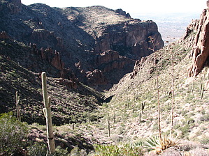
Awesome views to the North & Flatiron by CannondaleKid  Do you enjoy hiking to the Flatiron? Have you accomplished it more than once? Are you eager for a new vantage point to view Flatiron? Do you want some awesome panoramic views that are blocked somewhat on Flatiron? If you answered Yes to any/all of those questions, you'll definitely want to give this one a shot! Do you enjoy hiking to the Flatiron? Have you accomplished it more than once? Are you eager for a new vantage point to view Flatiron? Do you want some awesome panoramic views that are blocked somewhat on Flatiron? If you answered Yes to any/all of those questions, you'll definitely want to give this one a shot!Note: The stats for this hike reflect only the distance, time, and elevation gain from the point you leave and return to the Siphon Draw Trail #53. When planning this hike, make sure you allow for the time up from the Siphon Draw TH to the hike start point and back down again. Be sure to link either Flatiron or Siphon Draw Trail #53 to your triplog.
By this time, you will likely have made enough backtracks in your route, or at least you will have gained enough insight to choose your route more wisely. Either that or you may end up just bulling your way up to the top, but no matter, you'll soon be at the top of the ridge... and you will find the awesome views to the northeast well worth the efforts. Although you aren't yet at the summit, you'll have gained roughly 2,000' from the trailhead, so don't feel bad if you sit down and take a break. Ok, break's over, time for the relatively easy shuffle to the summit. Feel free to take your time because the views, especially from the northeast to the northwest, will drop your jaw in awe. The summit itself is almost as flat as a table for some distance, so it's almost an anti-climax, but you can make do by standing in the center of the square laid out with rocks next to a fire pit. Congratulations on reaching the summit of Peak 4175! You've earned it! If you've made it up in less time than expected (which was the case for us) and have enough time to use up before heading back (our descent took 1/2 the time of the ascent due to not having to scout our route), do take the time to wander westward. If you have another 30-60 minutes, head on over to Peak 4102 at the front, the most-westward edge of the Superstitions. Without trying too hard to stick to any pace, we made the trek up and back in just under 5 hours, 2:45 moving time and 2:10 stopped, mainly for taking photos and a few snack breaks. Check out the Official Route and Triplogs. Leave No Trace and +Add a Triplog after your hike to support this local community. | ||||||||||||||||||||||||||||||||||||||||||||||||||||||||||||||||||||||||||||||||||||||||||||||||||||||||||||||||||||||||||||||||||||||||||||||||||||||||||||||||||||||||||||||||||||||||||||