Route Editor

| Guide | ♦ | 6 Triplogs | 0 Topics |
details | drive | no permit | forecast | 🔥 route |
stats |
photos | triplogs | topics | location |
| 82 | 6 | 0 |
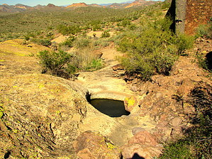
Hike from First Water Road to Saddle by Peak 2891 by AZLumberjack  This is a short and easy hike from a creek bed crossing along the First Water Trail to a saddle that is visible to the Southeast from the road and returning to the start. This is a short and easy hike from a creek bed crossing along the First Water Trail to a saddle that is visible to the Southeast from the road and returning to the start.The short hike can be done at any time of the day but the afternoon hours would provide better lighting for photographing the scenery. If you choose to hike in the early morning, expect the sun to shine in your eyes and spoil your best photos. Four Peaks is visible from many portions of the trail as is the nose of the Flatiron.
Once the trail gets steeper, walk on the flats where the creek has etched out a creek bed from the solid rock. This area should be a grand experience when the waters are flowing. There is a series of several riffles and pools for a long stretch and should be a photographer's dream. Continue to follow the creek, switching sides occasionally, to the saddle. From this nice flat area, you are looking down on the creek that flows from Massacre Falls and the confluence of a second stream that has its origins well up by the Peak 5024 of the mountain. The waters of the combined streams feed into First Water Creek. The coordinates of the saddle are 33.466767, -111.446167 From this saddle, it is possible to hike down and over to Massacre Falls and return via the Massacre Falls trail. A second continuing hike could take you to the First Water T H, or as a last choice, return the way you came in. This is a beautiful area and once you leave the horse trails, you should not expect to meet other hikers as there are no trail markers to direct them. Enjoy your hike and please keep the wilderness pristine. Check out the Official Route and Triplogs. Leave No Trace and +Add a Triplog after your hike to support this local community. | |||||||||||||||||||||||||||||||||||||||||||||||||||||||||||||||||||||||||||||||||||||||||||||||||||||||||