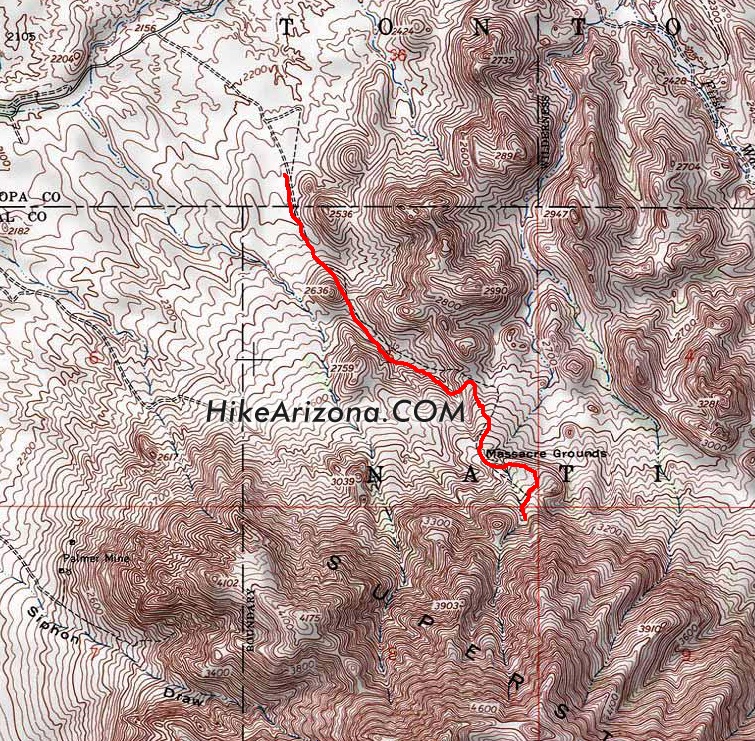
Massacre Falls hike heads east out of the Crosscut Trailhead. Use the Official Route for best results as the area changes over the years. It's 0.9-miles to the pre-2004 trailhead.
The old trailhead is seemingly in the middle of nowhere, with little trace of its existence. Walk through the fence, and the trail is wide and well defined. In season, wildflowers blanket the lower sections of this trail. Immediately to the left is a small knoll with some small caves. The trail heads towards a mini needle then passes it on the east. The trail works up to a low saddle crossing a usually dry creek three times.
Next comes the subtle ascent to the falls. When the creek is running, you can hear the falls in the distance. Otherwise, be on the lookout for the dark vertical stripe to the southeast. The stripe is one of the falls. From the low-lying saddle mentioned above to the falls is nothing challenging. However, it can be a route-finding challenge. My best advice is to study the map. Two or three cairned routes get you to the falls, and one takes you far away to West Boulder Canyon. Generally, the most traveled route brings you to the falls as it's the most popular destination in this area.
My route of choice is the red line on the map. When you're hiking in you, swear you are going wide to the east, which it does "slightly" but not by much. The old dashed line trail on the map is cairned too. Both routes work, and you probably won't know the difference on your first outing.
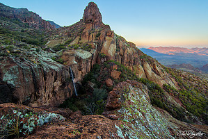
The trail goes through a tunnel of lush before delivering you to the east side of the Massacre Wall. Two falls pour over this wall. First encountered is the large waterfall on the east end. A short but steep canyon directly above the wall feeds this waterfall. It generally runs right after heavy rains. It pours off in a wide swath. This swath being the vertical stripe visible from distances far north into the wilderness. There is a nice spout on its left, which funnels water out from the wall. To the west is another waterfall. Although on the same wall, it's fed by a different drainage. This drainage goes all the way up to the Superstition Ridgeline and is much broader. Although longer and wider, it's not a solid rock surface. This waterfall flows upwards of a week after heavy rainfall employing the sponge effect.
Trail data provided is for an out-n-back hike to the waterfalls. On the return, consider the short excursion up a small ramp style ridge, which I've dubbed the "Massacre Ramp." It's easy to spot heading back and away from the falls. There are lovely 360-degree views from the top. There's also a sheer drop off. In fact, you're standing on an overhang if you're looking down. It kind of makes you take a step back when you look down, then notice there's no wall below.
Note #1: The actual "Massacre Grounds" aren't along this trail. Request for more information will not receive a response.
Note #2: Hike summary was revised on 04/02/04
2020-12-02 Guide updated to be less confusing about old access.
WARNING! Hiking and outdoor related sports can be dangerous. Be responsible and prepare for the trip. Study the area you are entering and plan accordingly. Dress for the current and unexpected weather changes. Take plenty of water. Never go alone. Make an itinerary with your plan(s), route(s), destination(s) and expected return time. Give your itinerary to trusted family and/or friends.
Permit $$
None
Directions
Road
High Clearance possible when dry
To Crosscut Trailhead From Mesa:
Follow US 60 east to Idaho Road. Turn North onto Idaho Road which is SR88 and follow it North 2.2 miles. SR88 bends right just past Scenic St. and Idaho continues North. Be sure to go right and stay on SR88. Follow SR88 5.2 miles to the signed turnoff for First Water Trailhead(large brown sign), this is FR78. Turn right onto FR78 and follow 0.6 miles to the large dirt parking lot which is the Crosscut Trailhead.
FR 78 is graded and passable for most low-clearance 2WD cars, but could be difficult after heavy summer rains. This trailhead is the traditional one for trail #58 and is frequently used as the fee-free alternative to hike the Flatiron and such.
From US 60 West: (Gold Canyon, Superior, etc)
Take Mountain View Rd north instead of Idaho Rd to save 5-6 miles. The turn for Mountain View Rd comes quickly after Silly Mountain. Turn right onto SR88.
Tip:
The crucial right turn onto FR78, is exactly 1 mile after the turn to Lost Dutchman.
From PHX (I-10 & AZ-51) 41.1 mi - about 52 mins From TUC (Jct 1-10 & Grant) 134 mi - about 2 hours 9 mins From FLG (Jct I-17 & I-40) 185 mi - about 2 hours 56 mins
 Route Editor

 Massacre Falls hike heads east out of the Crosscut Trailhead. Use the Official Route for best results as the area changes over the years. It's 0.9-miles to the pre-2004 trailhead.