Route Editor

| Guide | ♦ | 10 Triplogs | 0 Topics |
details | drive | no permit | forecast | 🔥 route |
stats |
photos | triplogs | topics | location |
| 115 | 10 | 0 |
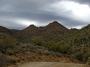
..No Hackberries but a nice Butte for 360 Views.. by Grasshopper  Overview OverviewOnly ~0.25 mile after the intersection of FR172/172A, a left turn (west) continuing on FR172, is the Park/TH Start for the "Millsite Canyon" hike at the intersection of FR172 and unsigned 4x4 mining road FR192B (FR1928). This partly off-trail hike to summit prominent "Hackberry Butte" at 4230 feet begins at the same TH location for the "Millsite Canyon" hike. For those qualified off-trail day hikers, this hike can provide a relatively short, easy-to-navigate, scenic, and historical added day hike #2 before or after your out and back hike into Millsite Canyon to the old Maverick Camp location. With the drive in and out and with attempting these two hike options in one day, would make for a long day out, but is possible (with or without this 2 in 1 option, this Hackberry Butte Summit hike is a winner in its self). Warning Do not be tempted to drive further up unsigned 4x4 mining road FR192B in an attempt to shorten your hiking day on this old mining road. This is a very dangerous driving road and can easily result in serious damage to your vehicle and/or worse.. to you and those riding with you. Hike it..don't drive it!
This partly "off-trail" hike begins as described above on FR192B (FR1928) and continues mostly uphill for approximately 1.0 miles where en-route you will have some excellent near and distant views of our eastern Superstition Wilderness- west toward the Woodbury TH and north toward the Rogers Trough TH. At this 1.0 mile mark up FR192B (at N33.39756 W111.21138) you will exit FR192B left (just before old fence line) at the semi-obvious, easy to navigate and mostly uphill ridgeline to begin the off-trail section to summit Hackberry Butte at 4230 feet. You will continue hiking, follow within sight of this old fence line which will be to your right. Following this ridgeline with some minimal uphill and down, you will reach an old fenced easy to miss (but don't miss it) "closed gate" (at N33.39142 W111.20741) approximately 1.5 miles in from your TH Start. Go through this crudely constructed wooden-wire gate and continue hiking up the ridge line with the old fence now to your left side sometimes in view and sometimes not. At approximately 1.8 miles in from your TH Start, you will top a rise to a most interesting location where some significant time and effort was devoted to building what this author believes is a long/wide rock fence the purpose of makes it difficult to figure.. why here? but it was a most interesting and unexpected find. Some pictures in my pic set will better depict this area find. Now continuing uphill with the summit in sight, you begin your last 0.20-mile segment with some easy to moderate bushwhacking and rock scrambling on a few loose spree areas as you make your final way up this sometimes steep ridgeline to top Hackberry Butte Summit at 4230 feet. You will want to spend some time on this summit to take in the really nice 360 degree short and long-distance views. Gate Policy: If a gate is closed upon arrival, leave it closed after you go through. If it is open, leave it open. Leaving a closed gate open may put cattle in danger. Closing an open gate may cut them off from water. Please be respectful, leave gates as found. The exception is signage on the gate directing you otherwise. Check out the Official Route and Triplogs. Leave No Trace and +Add a Triplog after your hike to support this local community. | ||||||||||||||||||||||||||||||||||||||||||||||||||||||||||||||||||||||||||||||||||||||||||||||||||||||||||