username
X
password
register
for free!
help
 This is likely a great time to hike this trail!  Check out "Preferred" months below, keep in mind this is an estimate.
  🔥

Sinkhole Trail #511 - Canyon Point Sinkhole, AZ

Guide 14 Triplogs  0 Topics
  2.8 of 5  
Fav
Wish
1
details
drive
no permit
forecast
🔥
route  
stats
photos
triplogs
topics
location
10 14 0
Statistics
tap row or icons for details
Difficulty 0.5 of 5
Distance One Way 0.75 miles
Trailhead Elevation 7,622 feet
Elevation Gain 54 feet
Accumulated Gain 57 feet
Kokopelli Seeds 0.94
unreported if dogs are allowed
editedit > ops > dogs to adjust
feature photo
Photos Viewed All MineFollowing
10  2013-07-01 Tortoise_Hiker
Author
author avatar Guides 16,843
Routes 17,472
Photos 24
Trips 1 map ( 6 miles )
Age 28 Male Gender
Location HAZ, TrailDEX
Associated Areas
list map done
Payson Region
Historical Weather
Trailhead Forecast
Radar Map
Expand Map
Preferred Sep, May, Jun, Aug
Sun  5:59am - 6:46pm
Official Route & 2 Rts
 
0 Alternative
 
Historic Fire Perimeteracres
🔥 2002 Rodeo-Chediski Fire233.5 mi**


 Likely In-Season!
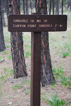
This well-marked walk to a sinkhole is a very nice hike. The hike starts within the spacious Canyon Point campground. The trail goes through the pine forest, through a fence, and into a more dense pine forest. After a short amount of flat hiking, the edge of the sinkhole is sighted.


Be sure to follow the trail into the sinkhole itself, as the forest in this area has a very magical feel to it. There is all manner of lush greenery here, including elusive ferns. At the bottom are some tree stumps that make for nice chairs to relax and reflect on this peaceful place.
remove free decal offer
When ready, return the way you came.

2018-07-14 HAZ_Hikebot


    Check out the Official Route and Triplogs.
    Leave No Trace and +Add a Triplog after your hike to support this local community.

    One-Way Notice
    This hike is listed as One-Way.

    When hiking several trails on a single "hike", log it with a generic name that describes the hike. Then link the trails traveled, check out the example.
    WARNING! Hiking and outdoor related sports can be dangerous. Be responsible and prepare for the trip. Study the area you are entering and plan accordingly. Dress for the current and unexpected weather changes. Take plenty of water. Never go alone. Make an itinerary with your plan(s), route(s), destination(s) and expected return time. Give your itinerary to trusted family and/or friends.

     Permit $$
    no fees or permits reported

    if incorrect tell us about it


     Directions
    or
     Road


    To hike
    To get to the trailhead: from the Phoenix area, take HWY-87 North toward Payson. Once in Payson, take HWY-260 East towards Heber. After 36 miles of driving, make a right at the signed turnoff to Canyon Point Campground. Take the B camping loop and keep an eye on your right for the trailhead.

    Note: The trailhead is a little tricky to find as it is buried inside a large campground.
    page created by tibber on Mar 04 2011 2:24 pm
     90+° 8am - 6pm kills
    helpcorrectionissue

    end of page marker