 Route Editor

| Guide | ♦ | 30 Triplogs | 0 Topics |
details | drive | no permit | forecast | 🔥 route |
stats |
photos | triplogs | topics | location |
| 234 | 30 | 0 |
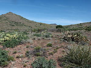
Rolling Hills to Sheep Creek by jacobemerick  Overview OverviewThis trail provides a fun, exposed ride over rolling hills to a scenic location nestled deep in the western Mazatzal Wilderness. It is surprisingly varied, swinging around hills, dipping into sandy washes, and even giving a bit of ridgeline fun near the end. Can be used with nearby trails to make good backpacking loops (see Davenport / Sears Loop or Copper Camp Loop II as examples. Warning The trail sees little usage, especially in the eastern end. Route-finding may be difficult.
Reaching the western trailhead involves a 3.3-mile walk from the Horseshoe Dam spillway along 479. Unless you can get a vehicle across the Verde River, that is, and then you can just drive to the trailhead and park alongside the road. From the posted trailhead there is a decision to make. The first option is to simply follow the posted route for 477, which crosses Davenport Wash and continues up the southern bank a short distance. Or some cairns lead a fox-tail path around the squat trees surrounding the wash. The cairned path does not seem to see much use. Either option will take you near the mucky Sears Trailhead Spring at .25 miles, one of the few springs along the trail. Once on the far side of the wash a sign for 'Copper Camp Trail 87' shows up, three miles before that trailhead, and another decision is presented. Stay straight on the barely defined two-track to follow the old tread back into Davenport Wash and, eventually, up the chalk-cliff cut. Or, turn right with the gravel road to find the newer trail alignment. The new alignment is well-defined, has plenty of cairns, and is only a little annoying to follow. It swings in and out along the upper banks of Davenport Wash, climbing little ridges and dropping into little drainages, eventually coming back to the chalk-cliff cut and a hard right turn at 1.38 miles. A well-defined two-track leads in between towering cliffs of chalk and makes a quick 150' climb onto a narrow flat. Near 2.0 miles there is a split, with the road swinging right and a cairned trail left. They join back up near the wilderness boundary. From here the way continues to be well-defined and well-cairned, leading through lush flats, over smooth rocky rises, and past a corral. There is a drop into a sandy, grassy wash at 4.1 miles that is easy to follow. A few ginormous trees are located along the wash that could provide good resting spots. While there are springs marked on the map along this stretch, I found them to be more stinky algae than water and passed them by on my visit in mid-April. Continue within the wash (unless you feel adventurous, then there are a few remaining trail segments along the banks) to 4.7 miles, then take the left fork a few dozen yards before following some cairns up and to the right along a narrow ridge between the two forks. The route begins to climb in earnest now up the ridge, then swinging along the side of 4032 to 5.4 miles. Here it begins to fade a bit and bend northwards across some washes and tops a saddle above Lizard Spring. Davenport Peak looks amazing from this saddle. Lizard Spring seems to be a year-round source, though reaching it does involve a nasty 200' off-trail descent. Sears Trail swings around the valley and gets close to an interesting frustron on Ridge Mountain. On the far side of this swing, past an old fence at 6.2 miles, is when route-finding becomes difficult. For a while, the trail plays on top of a ridge, with few cairns to help you with this obvious section. There are some awesome views of Cypress Ridge to the south along the ridge. Near 7.1 miles there is an eastern twist and a drop into the top of a small drainage, and then the route more-or-less aims for a saddle to the east. Beyond this saddle the trail stays level, keeping above a drainage of Sheep Creek and below the hillside to the north, curving northeast to the trail junction with Sheep Creek. There is a sign here, though it may be difficult to find. From here you can take Sheep Creek Trail either north or south. North will take you to Davenport Wash Trail and, eventually, Club Cabin. South will take you down to Round Spring and the old Sheep Creek Cabin area. Water Sources There are no dependable sources along the trail. Some of the seeps in the sandy wash may be running during the winter/spring months, and Lizard Spring seems to be dependable but involves some nasty off-trail venturing. Sheep Creek Cabin and Round Spring, beyond the end of Sears Trail, can provide some water relief at the end of the trail. Camping No obvious campsites along the route. Sheep Creek Cabin beyond the eastern end of the trail is a nice place to spend a night. Check out the Official Route and Triplogs. Leave No Trace and +Add a Triplog after your hike to support this local community. One-Way Notice This hike is listed as One-Way. When hiking several trails on a single "hike", log it with a generic name that describes the hike. Then link the trails traveled, check out the example. | ||||||||||||||||||||||||||||||||||||||||||||||||||||||||||||||||||||||||||||||||||||||||||||||||||||||||||||||||||||||||||||||||||||||||||||||||||||||||||||||||||||||||||||||||||||||||||||||||||||||||||||||


