Route Editor

| Guide | ♦ | 2 Triplogs | 0 Topics |
details | drive | permit | forecast | map |
stats |
photos | triplogs | topics | location |
| 18 | 2 | 0 |
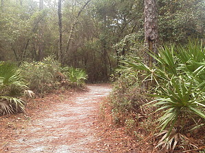
Quaint Forest Peace by satillayakker The trail is relatively short by most hike standards, but very well worth the time. The trailhead is located just off of a scenic drive that winds its way through southern pine forests and swamps in part of the Dixon Memorial State Forest. On beginning, the trail seems to be not much of anything special. For a half mile or so, you are walking through clean pine plantations showing signs of a wildfire we had here a few years ago. The white dirt in the pines is a favorite for gopher tortoises, which are very easy to find here if you just get some guidance from locals on how to spot the dens. Various species of woodpeckers are also common there. As you move on, there is a drop in elevation as you follow the trail into a swampy creek bottom. But no worry, the trail is very well maintained and wide. Along the creek bottom portion of the trail, you can see turtles, occasionally an alligator, and white-tailed deer. Black bears and bobcats have also been seen along the trail, as the area is near many large swamps, a favorite of both. As you leave the creek bottom, you return to the planted pines for the remainder of the hike.
Note: Trail parking lot closes at sunset. Camping is available on connector near trail. Check out the Triplogs. Leave No Trace and +Add a Triplog after your hike to support this local community. | |||||||||||||||||||||||||||||||||||||||||||||||||||||||||||||||||||||||||||||||||||||||||||