 Route Editor

| Guide | ♦ | 73 Triplogs | 2 Topics |
details | drive | permit | forecast | route |
stats |
photos | triplogs | topics | location |
| 1.1k | 73 | 2 |
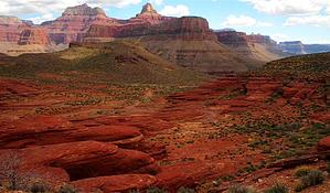
Not in Utah and not flat! by nonot   Overview OverviewA somewhat popular off-trail route in the Grand Canyon connects the Bright Angel Campground Area near Phantom Ranch to Upper Phantom Creek. It is popular as a backpacking option since most will stay in upper Phantom Creek for a day or two. It doesn't make that great of a day hike, in my opinion. Warning This is considered off-trail by the park service and is neither maintained nor patrolled. Part of the route is faint, and you will need to exercise route-finding skills to find where it continues. The climb out of Bright Angel is hot, and I recommend an early start.
Discovered quite awhile ago, this route was found as a way to explore west of the North Kaibab trail without having to get drenched hiking up Phantom Canyon. It is named Utah flats because the early route-finders thought the rock masses that you reach upon completing the climb out of the campgrounds somewhat resemble the slickrock flats of Utah. Hike From the north end of the Bright Angel Campground, next to the solid-looking gray bridge on the west side of bright angel creek, you will find a faint trail (no signs) that goes around a bush or two and begins a steep ascent up the talus slope to the northwest. The footing is loose and the slope is about 40 degrees or so towards the beginning. Shortly you cross underneath the trans-canyon phone line and continue some minor switchbacks as you continue up very steeply. The first resting spot is a flat-topped knob about 200 feet above camp. There is another good spot with shade about 500 feet above the campground. After this, you will emerge onto a bare gray saddle into full sun. Looking forward, you will see what is called "Piano Alley" due to the large number of fallen boulders the size of pianos (and many are much bigger). The trail will continue climbing up the right side of the gully, taking you around most of the large boulders. Once you hit the cliff wall on the right side, you will run out of trail and eventually have to do some minor climbing (class 2 YDS) up the boulders for about 200 feet. It is a bit of a scramble, but there are several ways to get through the boulder field, and it is not too difficult to do with your pack on. As you complete the climb, you will end up in a minor gully and continue walking up the gully until you can find a convenient place to climb up the rocks to your right to reach a flat layer. Once standing here, you can look around and begin to understand why they named this Utah Flats. Signs of a trail are virtually nonexistent here, so set your compass to the northwest and begin traversing over the brownish "slickrock" and gravel. Conserving your elevation, you will wind around a bit of a depression, with more "slickrock" blobby masses to your north. If you are lucky, you will eventually pick up a faint trail (quite faint) as you climb up towards what is called "Cactus Saddle," which is a minor saddle on a hill filled with small cactus. Finding the trail here is crucial and may take a bit of wandering around, but after this, the trail proceeds to climb quite a bit, and you really wouldn't want to do the next part without finding the route again. The trail climbs and contours its way up the slopes of Cheops to try to reach a flatter layer a few hundred feet up. The trail the rest of the way is reasonably good, and it weaves its way around Cheops with some ups and downs as it begins to approach Phantom Creek. Finally, after slightly passing the Cheops-Isis saddle (a few hundred feet below it), the trail will start to go steeply down, then up a bit, and then steeply down towards the creek. The footing is poor in some places, so use caution and take your time. It is steep and just about as unpleasant as the way up from Phantom at the beginning. As you reach the bottom, you will see a nice campsite on the other side of the creek. The route ends depositing you in the upper part of Phantom Creek. About a hundred yards downstream is the barrier falls in Phantom Creek that is about 20 feet high. Water Sources The Bright Angel campground has running potable water. At the end of this hike, you will reach Phantom Creek, which is perennial. Water may be found in the "Utah Flats" area itself above Piano Alley shortly after rains. Camping Campers can camp in the "Utah Flats" area above Piano Alley, camping further down towards Bright Angel is not permitted. At the end of this route in Phantom Creek, there is a camping area you will see as you descend. It is very nice, but if rain is predicted, it may be miserable due to the way water falls off the cliffs. Notes This is not to be confused with the Bonzai route, that is a different, steeper route up a gully. Check out the Official Route and Triplogs. Leave No Trace and +Add a Triplog after your hike to support this local community. One-Way Notice This hike is listed as One-Way. When hiking several trails on a single "hike", log it with a generic name that describes the hike. Then link the trails traveled, check out the example. | ||||||||||||||||||||||||||||||||||||||||||||||||||||||||||||||||||||||||||||||||||||||||||||||||||||||||||||||||||||||||||||||||||||||||||||||||||||||||||||||||||||||||||||||||||||||||||||


