username
X
password
register
for free!
help


Koko Crater Railway Trail, HI

Guide 7 Triplogs  0 Topics
  4 of 5  
Fav
Wish
0
HI > Oahu
details
drive
no permit
forecast
route  
stats
photos
triplogs
topics
location
47 7 0
HAZ reminds you to respect the ruins. Please read the Archaeological Resources Protection Act of 1979 & Ruins Etiquette
Statistics
tap row or icons for details
Difficulty 4 of 5
Route Finding 1 of 5
Distance Round Trip 1.72 miles
Trailhead Elevation 213 feet
Elevation Gain 925 feet
Accumulated Gain 1,004 feet
Avg Time Round Trip 1-2 hours
Kokopelli Seeds 6.74
 Interest Ruins, Historic & Peak
 Dogs not allowed
feature photo
Photos Viewed All MineFollowing
Inaugural Calculation on Button Tap!
9  2023-10-18 The_Eagle
8  2022-05-23 squatpuke
9  2016-05-18 Lucyan
12  2015-08-26 Lucyan
7  2013-08-30 zukerrach
2  2011-03-25 hminaz
Author
author avatar Guides 41
Routes 1,626
Photos 14,983
Trips 2,760 map ( 18,597 miles )
Age 69 Male Gender
Location Far NE Phoenix, Az
Associated Areas
list map done
Honolula Region
Historical Weather
Trailhead Forecast
Radar Map
Expand Map
Preferred Jan, Jan, Jan, Jan → 7 AM
Sun  6:15am - 6:44pm
Official Route & 2 Rts
 
0 Alternative


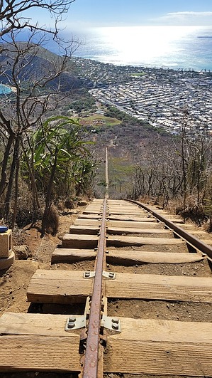
Stairway to Heaven
by The_Eagle

 
The Koko Crater Railway Trail is on the southeastern edge of Oahu, Hawaii. It is an example of man's engineering prowess and a challenging hiking trail.


The Koko Crater Railway Trail was built during World War II. The U.S. military established Camp Koko Head, a coastal defense installation. The now iconic "Koko Head Stairs" were once used by soldiers to transport supplies and ammunition to the mountaintop. 1,048 uneven and steep steps will test your endurance and provide panoramic views of the Pacific Ocean and the surrounding areas.
remove free decal offer
The hike begins at Koko Head Regional Park. As you climb the stairs, the views open up to the surrounding area.

At the summit, you are rewarded with views of Hanauma Bay and the eastern coast of Oahu.

If you are adventurous enough, you can also include the route around the rim of the crater.

2023-11-01 The_Eagle


    Check out the Official Route and Triplogs.

    Note
    This is a moderately difficult hike.
    Leave No Trace and +Add a Triplog after your hike to support this local community.
    WARNING! Hiking and outdoor related sports can be dangerous. Be responsible and prepare for the trip. Study the area you are entering and plan accordingly. Dress for the current and unexpected weather changes. Take plenty of water. Never go alone. Make an itinerary with your plan(s), route(s), destination(s) and expected return time. Give your itinerary to trusted family and/or friends.

     Permit $$
    None


     Directions
    or
     Road
    Paved - Car Okay

    To hike
    From HI-72
    Turn NE onto Lunalilo Home Rd
    Turn right onto Anapalau St
    Turn left
    Destination will be on the left
    page created by joebartels on Oct 31 2023 10:51 pm
     90+° 8am - 6pm kills
    helpcorrectionissue

    end of page marker