Route Editor

| Guide | ♦ | 61 Triplogs | 0 Topics |
details | drive | no permit | forecast | route |
stats |
photos | triplogs | topics | location |
| 464 | 61 | 0 |
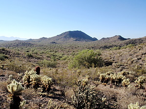
Loop de Loop by MEWhiteman  Overview OverviewThe Phoenix Sonoran Preserve is a relatively new park in northwest Phoenix where the city is beginning to build hiking trails. A year ago the Dixie Mountain Loop (originally called Sonoran Loop) was built and now additional trails have been constructed or are under construction opening up other sections of the park for hikers. This description is for a hike beginning at the trailhead at the Fireside development near North Valley Parkway and leading to the summit of Peak 2383 to the east and back forming a lasso loop. There are some great views especially from the summit and hiking through typical desert terrain. There will be more options as new trails are constructed, but for now, this can be done as a lasso loop or an out and back. I have not indicated every junction. The trail constructors have blocked off old trails and roads which are not part of these new trials. They've used piles of dirt, rocks, or sticks or have "plowed" or "gouged" the old trials to keep them from being used and to allow them to return to desert. The trail you want to follow is evident from the well-built dirt track. Hike Beginning at the trail signs at the northeast corner of the parking hike north on the Hawks Nest Trail. At 0.41 miles (N33 44.691 W112 05.580) turn right at the junction with Dixie Mountain Loop Trail. For more information on this trail see Union Hills Loop. At 0.85 miles (N33 44.842 W112 05.224) turn right, downhill, on a new trail, unnamed at the time of this description. This goes downhill for a short while then tends to level out and gradually lose some elevation over the next mile before the climbing begins. At 1.85 miles (N33 44.328 W112 04.764) turn right. The trail straight ahead at this point is the north loop, but this description focuses on the summit and south loop. After the turn at 2.05 miles (N33 44.146 W112 04.741) keep left avoiding an old gravel road. At 2.10 miles (N33 44.116 W112 04.713) continue straight past junction with the trail coming in from the right. This trail coming in is the end of the south loop and where you'll be returning if doing the loop. Now the climbing begins. If you look down to the right you'll see the loop trail as it returns to join this trail.
After turning right follow the trail downhill. At 3.92 miles (N33 43.976 W112 03.970) turn right at a junction. The trail coming in from the left is the other end of the north loop which began at mile 1.85 of this hike. This part of the trail, the south loop, circles a bowl on the south side of the peak. You'll go through some washes, past some houses and get some more views. At 5.22 miles (N33 43.638 W112 04.670) keep right to avoid a local trail. Now you'll climb some more to reach the junction with the trail you came in on at 6.05 miles (N33 44.116 W112 04.713). At this point, turn left and follow the trails you came in on reaching the trailhead in 8.13 miles. It's taken a few months for the trail constructors to finish this trail, but they've done a great job. It's a nice hike and worth the effort. Check out the Official Route and Triplogs. Leave No Trace and +Add a Triplog after your hike to support this local community. | ||||||||||||||||||||||||||||||||||||||||||||||||||||||||||||||||||||||||||||||||||||||||||||||||||||||||||||||||||||||||||||||||||||||||||||||||||||||||||||||||||||||||||||||||||||||||||||