Overview
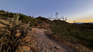
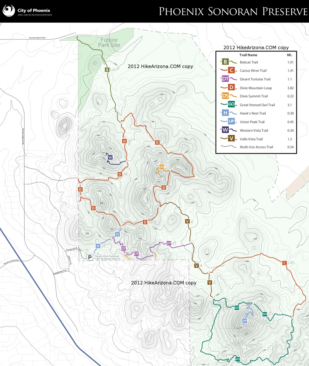
Dixie Mountain Loop is an enjoyable moderate/easy rollercoaster loop trail. Most access this trail from Desert Vista Trailhead to the south, hiking Hawk's Nest Trail 0.4 mi to the loop. The neighborhood to the north hikes in 1.0 mile via Bobcat Trail.
Hike
From the end of Hawk's Nest Trail, the question at hand is which direction is best. The park suggests counter-clockwise for smaller ascents. Perhaps but the trail grade is subtle regardless. Either direction has incredible sunrises but the east is most iconic with the Four Peaks. Narration is CCW since the majority of hikers favor the out-n-back hike to Dixie Summit Trail.
Heading east has little elevation change for a quarter-mile to the west slope of 2146. On the SE side of 2146, Valle Vista Trail begins at ~0.43 mi. The trail continues in and out of a large ravine and into the next where it meets Dixie Summit Trail at ~0.93 mi. Which I've dubbed Dixie Saddle.
From Dixie Saddle, the trail circumvents an unnamed/unnumbered peak dropping 350 ft to the low point. This NW segment was my favorite. Fab views, less trail activity, and occasional zen. The low point of the loop is just before the junction with Bobcat Trail in a tributary of Sonoran Wash. After a quick rise to Bobcat, it ascends south up to the inner saddle passing Western Vista Trail at 2.65 mi. Teddy Bear Cholla is healthy and thick for a good stretch. With an excellent trail and moderate traffic, fallen cholla balls on the trail were zero on my recent visits.
Continuing is my next favorite segment back to Hawk's Nest Trail. Pyramid Peak is the distinct distant view as you are now heading directly west, dropping through a large ravine at 2.95 mi. A rusted truck frame remains from a 1998 tragedy in the ravine at 3.1 mi.
Finishing up around the westernmost side are two junctions with connector trails into the neighborhood community trail system. While I enjoy the distant mountains there was a notable hum from I-17(1.5 mi) or North Valley(0.5 mi) Parkway on my two hikes. A little surprising I don't hear any of that hum on Piestewa from SR51(1.0 mi).
Popular Hike Stats
4.65-mi / 800 AEG -- Lasso Loop from Desert Vista TH
4.15-mi / 925 AEG -- Western Vista(2080) Out-n-Back
3.15 mi / 665 AEG -- Dixie Summit Out-n-Back
Synopsis
A well-designed trail, well-maintained that makes a low-key hike enjoyable with constantly changing views. Caters well to non-aggressive hikers, mountain bikers, and runners.
Original Description by hippiepunkpirate
This was the first new trail built, 2010, in the Sonoran Preserve. Look for the Teddy Bear Cholla forest between mileposts 2.6 and 2.75.
WARNING! Hiking and outdoor related sports can be dangerous. Be responsible and prepare for the trip. Study the area you are entering and plan accordingly. Dress for the current and unexpected weather changes. Take plenty of water. Never go alone. Make an itinerary with your plan(s), route(s), destination(s) and expected return time. Give your itinerary to trusted family and/or friends.
Permit $$
None
Directions
Road
Paved - Car Okay
To Desert Vista Trailhead From I-17 and Jomax Rd, take Jomax to it's east end. Turn left on North Valley Pkwy, right on Copperhead Trail, left on Melvern Trail, and right on Desert Vista Trail to go behind the neighborhood community center. Desert Vista dead ends at the trailhead parking lot. Studying a map before you go is recommended as the trailhead is somewhat hidden in the neighborhood.
Address: 1901 W Desert Vista Trail, Phoenix
From PHX (I-10 & AZ-51) 29.4 mi, 34 mins From TUC (Jct 1-10 & Grant) 134 mi, 2 hours 4 mins From FLG (Jct I-17 & I-40) 122 mi, 1 hour 54 mins
 Route Editor

 Overview